Filter: Categories of Wisconsin Historical Images
Filter: Subject of Mountains
Filter: Subject of water
Filter: Year of 1800-1899
Filter: Categories of Wisconsin Historical Images
Filter: Subject of Mountains
Filter: Subject of water
Filter: Year of 1800-1899
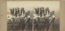
| Date: | 1864 |
|---|---|
| Description: | Albumen stereograph of the Union Army brass band posed and playing atop Lookout Point. The Tennessee River is in the background. |

| Date: | 1850 |
|---|---|
| Description: | Pic Island on the north shore of Lake Superior. |

| Date: | 1832 |
|---|---|
| Description: | Fort Union, on the Missouri River in Montana. |

| Date: | 1832 |
|---|---|
| Description: | Fort Clark, on the Missouri River, February 1834. |
| Date: | 1832 |
|---|---|
| Description: | The White Castles, on the Upper Missouri River. |

| Date: | 02 21 1874 |
|---|---|
| Description: | African American boatmen run a rapids in a small river boat. |

| Date: | 1893 |
|---|---|
| Description: | Front and back covers of an advertising brochure for the New Empire line of mowers, reapers and grain binders manufactured by J.F. Seiberling & Company. Th... |

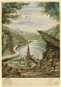
| Date: | 1854 |
|---|---|
| Description: | Drawing of the Porcupine Mountains on Lake Superior. A deer is standing in the lake drinking water. A man is on the rock ledge above the shoreline and is a... |
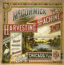
| Date: | 1880 |
|---|---|
| Description: | Cover of a McCormick Harvesting Machine Company fair circular (catalog). The cover is illustrated with a lake and mountain scene and includes the text "Man... |
| Date: | 1857 |
|---|---|
| Description: | Business with Frank Leslie's Illustrated Newspaper took Hölzlhuber to New York, and from there he also visited Philadelphia, Baltimore, and Washingt... |
| Date: | 07 31 1849 |
|---|---|
| Description: | Bear Valley in Utah; sketched by Wilkins on his 151-day journey from Missouri to California on the Overland Trail (also known as the Oregon Trail). Wilki... |
| Date: | 08 01 1849 |
|---|---|
| Description: | Bear Valley in Utah; sketched by Wilkins on his 151-day journey from Missouri to California on the Overland Trail (also known as the Oregon Trail). Wilki... |
| Date: | 08 03 1849 |
|---|---|
| Description: | Steam Boat Springs in Idaho; sketched by Wilkins on his 151-day journey from Missouri to California on the Overland Trail (also known as the Oregon Trail).... |
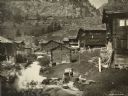
| Date: | 1895 |
|---|---|
| Description: | Houses by a stream in Zermatt, Switzerland. A woman is doing laundry (?) in the foreground. |

| Date: | 11 26 1883 |
|---|---|
| Description: | A hand-drawn map of the Clinch and Powell's Valleys, including the Cumberland Mountains, Powell's Mountains and Clinch Mountains. |
| Date: | 1866 |
|---|---|
| Description: | View towards the Allatoona Pass from behind earthworks overlooking the Etawah River. A railroad bridge crosses the river on the right. Plate 24 |

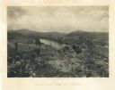
| Date: | 1866 |
|---|---|
| Description: | View along earthworks overlooking the Etawah River and a railroad bridge. A tree stripped of branches and bark is on the left. Plate 23 |
If you didn't find the material you searched for, our Library Reference Staff can help.
Call our reference desk at 608-264-6535 or email us at: