 Filter: Categories of Wisconsin Historical Images
Filter: Subject of Ocean
Filter: Reproduction Rights of For Sale
Filter: Categories of Wisconsin Historical Images
Filter: Subject of Ocean
Filter: Reproduction Rights of For Sale

| Date: | 1886 |
|---|---|
| Description: | Advertisement for the Atchison, Topeka and Santa Fe Railroad featuring an illustration of Uncle Sam stretched from the Missouri River to the Pacific Ocean.... |
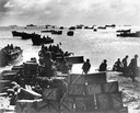
| Date: | 1944 |
|---|---|
| Description: | Original caption reads: "Coast guardsmen shuttle landing craft back and forth from the anchorage to the beach of Eniwetok Atoll, bringing in fighters and s... |

| Date: | 1655 |
|---|---|
| Description: | Christopher Columbus begins his first expedition, 1492. |

| Date: | 1655 |
|---|---|
| Description: | Encounter with Indians during Christopher Columbus' first expedition in 1492. |

| Date: | 1655 |
|---|---|
| Description: | Map from Drake Expedition, ca. 1585. |

| Date: | 1784 |
|---|---|
| Description: | Plate 57. Scene from Cook's Third Expedition, 1776-1779, while in Alaska. |
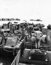
| Date: | 1944 |
|---|---|
| Description: | U.S. Marines unloading equipment and vehicles from supply ships at Guam beach. International M-5-H-65 trucks are in the background. |

| Date: | 1831 |
|---|---|
| Description: | Map of the United States "constructed from the latest authorities," including a statistical table. |
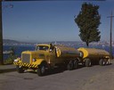
| Date: | 1951 |
|---|---|
| Description: | Color photograph of an International LD-400 series tanker truck owned by Eastern Washington Transports, Inc., on a road near the Port of Seattle. |

| Date: | 1938 |
|---|---|
| Description: | A colorful pictorial map of Australia, featured on the front and back cover of a special Australian edition of International Trail. |
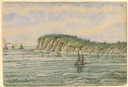
| Date: | 1856 |
|---|---|
| Description: | At the beginning of his journey to America, Hölzlhuber passed through the English Channel and viewed the cliffs at Dover. "We passed Beachy Head, as this p... |

| Date: | 1856 |
|---|---|
| Description: | While passing through the English Channel in May 1856 Hölzlhuber viewed the Isle of Wight. "The island is located in the English Channel not far from Hamps... |
| Date: | 1856 |
|---|---|
| Description: | The Tuisco left Bremerhaven May 6, 1856. Hölzlhuber called this the "quickest three masted immigration boat," holding 335 passengers. Though in the ... |
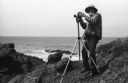
| Date: | 1968 |
|---|---|
| Description: | Photographer Ansel Adams mounting his Hasselblad camera onto the tripod on a rocky shore near or at Point Lobos. |
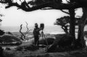
| Date: | 1968 |
|---|---|
| Description: | Photographer Ansel Adams setting up his camera in a wooded waterfront area near Point Lobos. |
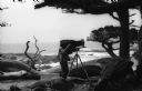
| Date: | 1968 |
|---|---|
| Description: | Photographer Ansel Adams under his dark cloth looking through the groundglass of his 8 x 10 field camera in a wooded area near Point Lobos. The Pacific Oce... |
| Date: | 12 07 1941 |
|---|---|
| Description: | Sailors clear the stern of the battleship USS West Virginia in berth F-6 at Pearl Harbor, most likely after it was hit by at least a few of the 7 to... |

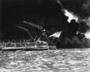
| Date: | 12 07 1941 |
|---|---|
| Description: | The forward magazines of the USS Shaw exploding after a Japanese bomb set the fore aflame as it sat in dock at Pearl Harbor. The midships and stern ... |
If you didn't find the material you searched for, our Library Reference Staff can help.
Call our reference desk at 608-264-6535 or email us at:

