 Filter: Categories of Wisconsin Historical Images
Filter: Subject of Ocean
Filter: Subject of transportation
Filter: Categories of Wisconsin Historical Images
Filter: Subject of Ocean
Filter: Subject of transportation

| Date: | 1784 |
|---|---|
| Description: | Plate 57. Scene from Cook's Third Expedition, 1776-1779, while in Alaska. |

| Date: | 1831 |
|---|---|
| Description: | Map of the United States "constructed from the latest authorities," including a statistical table. |
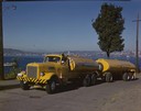
| Date: | 1951 |
|---|---|
| Description: | Color photograph of an International LD-400 series tanker truck owned by Eastern Washington Transports, Inc., on a road near the Port of Seattle. |

| Date: | 1938 |
|---|---|
| Description: | A colorful pictorial map of Australia, featured on the front and back cover of a special Australian edition of International Trail. |
| Date: | 1856 |
|---|---|
| Description: | At the beginning of his journey to America, Hölzlhuber passed through the English Channel and viewed the cliffs at Dover. "We passed Beachy Head, as this p... |

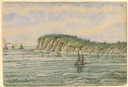
| Date: | 1856 |
|---|---|
| Description: | While passing through the English Channel in May 1856 Hölzlhuber viewed the Isle of Wight. "The island is located in the English Channel not far from Hamps... |
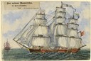
| Date: | 1856 |
|---|---|
| Description: | The Tuisco left Bremerhaven May 6, 1856. Hölzlhuber called this the "quickest three masted immigration boat," holding 335 passengers. Though in the ... |
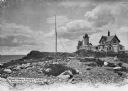
| Date: | |
|---|---|
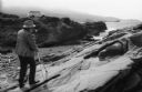
| Description: | Eastern Point Lighthouse at "Mother Ann" and residence on rocky point, Gloucester, Massachusetts. Mother Ann is a rocky cliff at the far south end of Easte... |
| Date: | 1968 |
|---|---|
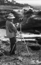
| Description: | Ansel Adams with a Hasselblad camera mounted on a tripod prepares to make a photograph at Point Lobos. His International Travelall is in the background. |
| Date: | 1968 |
|---|---|
| Description: | Ansel Adams takes a light reading with a hand-held light meter in front of his tripod mounted Hasselbald. His International Travelall is in the background. |
| Date: | |
|---|---|
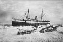
| Description: | View of a ship in the spring on the edge of the ice five miles off Nome. On shore, sleds and sled dogs are in the foreground. Caption reads: "The first boa... |

| Date: | 1857 |
|---|---|
| Description: | Information depicting the history, condition and prospects of the Indian tribes of the United States: collected and prepared under the direction of the Bur... |

| Date: | 1798 |
|---|---|
| Description: | Uncolored. No scale. One of the earliest maps to show the proposed division of the northwest territory into states. |

| Date: | 1813 |
|---|---|
| Description: | Eastern half of the United States. Scale: 2.5 inches = 250 miles. |

| Date: | 1850 |
|---|---|
| Description: | [... through northern United States from New York to Minnesota]. Lithography by T. Sinclair. From Perrault papers, Lucien S. Hanks, donor. |

| Date: | 1755 |
|---|---|
| Description: | From "A map of the British and French dominions in North American with the roads, distances, limits, and extent of the settlements". |

| Date: | 1772 |
|---|---|
| Description: | Scale: about 180 miles to 1 in. |

| Date: | 1755 |
|---|---|
| Description: | Color map of North American territories owned by the English and by the French. Scale: about 115 milles d'Angleterre to 1 inch. French title is "Carte des ... |

| Date: | 1824 |
|---|---|
| Description: | Drawn and engraved by Sidney Hall. Published by Longman, Hurst, Rees, Orme, Brown & Green. Scale: 1:200. Partly colored. This is probably the second Europe... |
| Date: | 04 20 1944 |
|---|---|
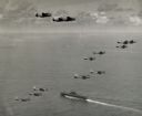
| Description: | Aerial view of three TBF's (all above the horizon) and eleven SBD's, which participated in Pacific Fleet's carrier-strike against Japan's bases in the Pala... |
If you didn't find the material you searched for, our Library Reference Staff can help.
Call our reference desk at 608-264-6535 or email us at: