 Filter: Categories of Wisconsin Historical Images
Filter: Subject of Orchards
Filter: Subject of water
Filter: Categories of Wisconsin Historical Images
Filter: Subject of Orchards
Filter: Subject of water
| Date: | |
|---|---|
| Description: | Picnic Point from University drive, currently known as Observatory Hill. There are orchards in the foreground. |
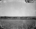
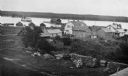
| Date: | 1920 |
|---|---|
| Description: | A view of a rolling rural landscape, most likely in Sauk County. In the far distance are houses and farm buildings, a church and a larger building, center ... |
| Date: | 05 1924 |
|---|---|
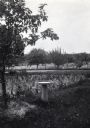
| Description: | View of a birdbath standing among trees at Holden Farm. In the background behind a wire fence, chickens are in an orchard. |
| Date: | 1920 |
|---|---|
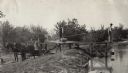
| Description: | Three men in an orchard mixing up chemicals to spray the trees. One of the men is on the back of a horse-drawn wagon with a barrel. The other two men are s... |

| Date: | 1916 |
|---|---|
| Description: | This Wisconsin Conservation Commission map from 1916 shows Peninsula State Park in the Town of Gibraltar, Door County, Wisconsin. Depicted are open and pla... |

| Date: | 1916 |
|---|---|
| Description: | This version of a 1916 Wisconsin Conservation Commission map shows Peninsula State Park in the Town of Gibraltar, Door County, Wisconsin. Depicted are open... |

| Date: | 1930 |
|---|---|
| Description: | Aerial view over northern Door County, looking northeast across Europe Lake and Europe Bay toward Plum and Washington Islands. Farm fields and orchards con... |
| Date: | 1915 |
|---|---|
| Description: | Elevated view of Fish Creek Harbor as a boat approaches the pier and warehouse. In the foreground are houses with outbuildings, gardens and a small orchard... |

| Date: | 1915 |
|---|---|
| Description: | This map of Door County, Wisconsin, from the early 20th century shows roads, schools, churches, creameries and cheese factories, orchards, docks, quarries,... |
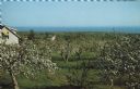
| Date: | |
|---|---|
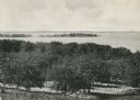
| Description: | Elevated view of an orchard during apple blossom season, with Lake Superior in the distance. |

| Date: | 1873 |
|---|---|
| Description: | A map of the township of Primrose from the "Atlas of Dane County." |

| Date: | 1873 |
|---|---|
| Description: | A map of the township of Montrose from the "Atlas of Dane County." |

| Date: | 1871 |
|---|---|
| Description: | This map shows buildings, roads, the railroad, an orchard, and swamp land. Relief shown by hachures. The map includes an index of buildings in the upper ri... |

| Date: | 1770 |
|---|---|
| Description: | The south west sheet of a four sheet map of Virginia, showing the counties, mountains, rivers, court houses, a few cities, and mills. A few Plantations ar... |

| Date: | 03 1777 |
|---|---|
| Description: | Map showing the British and Hessian attack on Fort Washington in November of 1776. The movements and fortifications of the British and Hessian troops appea... |
If you didn't find the material you searched for, our Library Reference Staff can help.
Call our reference desk at 608-264-6535 or email us at: