 Filter: Categories of Wisconsin Historical Images
Filter: Subject of Ponds
Filter: Creator Name of Unknown
Filter: Subject of rivers
Filter: Categories of Wisconsin Historical Images
Filter: Subject of Ponds
Filter: Creator Name of Unknown
Filter: Subject of rivers

| Date: | 1874 |
|---|---|
| Description: | Bird's-eye map of Chippewa Falls. |
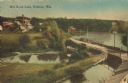
| Date: | 1905 |
|---|---|
| Description: | Elevated view of a pond, a stream, and a lake, with a road dividing the pond and stream from the lake. Industrial buildings and a smokestack are in the bac... |
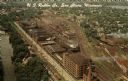
| Date: | |
|---|---|
| Description: | Aerial view of the plant, with railroad tracks along both sides of the property. A river is on the left. Several cars are parked at the plant. There is an... |

| Date: | 1825 |
|---|---|
| Description: | Portion of a map showing a survey of Lake Superior including the River St. Louis. |

| Date: | 1905 |
|---|---|
| Description: | View of the lagoon and surrounding wooded area in Tenney Park. Caption reads: "Lagoon in Tenney Park, Madison, Wis." |

| Date: | 1907 |
|---|---|
| Description: | Bridge and Lagoon in Tenney Park. Caption reads: "Bridge and Lagoon, Tenney Park, Madison, Wisconsin." |
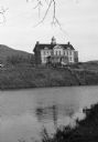
| Date: | |
|---|---|
| Description: | View from shoreline across water toward an unidentified school building with an ornate bell tower on the roof on the bank of a river or large pond. A hill ... |

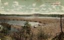
| Date: | |
|---|---|
| Description: | Two views of the Prairie Dells dam site including the pond, the falls and the power house. |

| Date: | 1900 |
|---|---|
| Description: | This map of Bangor is ink and pencil on cloth. The map shows roads, railroads, residences, mills, the original plat of Bangor, and the Wisconsin and Wheldo... |

| Date: | 1873 |
|---|---|
| Description: | A map of the township of Montrose from the "Atlas of Dane County." |

| Date: | 1909 |
|---|---|
| Description: | View across river toward the mill and dam. Caption reads: "Glen Lock Dam and Mill, Chippewa Falls, Wis." |
| Date: | 1910 |
|---|---|
| Description: | A colored photographic postcard view of a large log jam in the Dells Pond at Eau Claire. There are "booms" and several men standing on logs. Caption reads:... |

| Date: | 1896 |
|---|---|
| Description: | This map shows plat of town, local streets, numbered blocks and lots, mill pond, mills, part of the Red Cedar River, and land and property ownership by nam... |

| Date: | 1900 |
|---|---|
| Description: | This map shows logging roads, railroads with spur lines, trails, rapids, lumber camps, Indian villages, summer resort, lakes, rivers, and ponds. |

| Date: | |
|---|---|
| Description: | View across pond towards three boys standing on the board walkway of the spillway at Lake Mendota and the Yahara River. In the background is the far shorel... |

| Date: | 1910 |
|---|---|
| Description: | This set of manuscript blueprint maps show block and lot numbers, railroads, and some landownership, including lands and buildings of J.S. Owen Lumber Co. ... |

| Date: | 1789 |
|---|---|
| Description: | Map of New York City showing ward boundaries, ferries, streets, roads, swamps, ponds, and rivers. The properties of Lispinard, Byards, Jones, Rutgers, and ... |

| Date: | 1776 |
|---|---|
| Description: | Fairly detailed map of New York City and parts of Long Island. It shows streets, roads, wharves, ferries, ship yards, Fort George and the battery, public b... |

| Date: | 1931 |
|---|---|
| Description: | A plat map of Springfield, Wisconsin. |

| Date: | 1912 |
|---|---|
| Description: | A plat map of the township of West Kewaunee. |
If you didn't find the material you searched for, our Library Reference Staff can help.
Call our reference desk at 608-264-6535 or email us at: