 Filter: Categories of Wisconsin Historical Images
Filter: Subject of Prairies
Filter: Categories of Wisconsin Historical Images
Filter: Subject of Prairies

| Date: | 1848 |
|---|---|
| Description: | Wisconsin became the thirtieth state in 1848. Drawn that same year, this map shows township lines, roads, villages, mills, railroads, prairies, swamps, can... |

| Date: | 1849 |
|---|---|
| Description: | Published in Germany a year after Wisconsin entered statehood, this map shows prairies, swamps, lakes, mounds, limestone deposits, and lead and copper mine... |
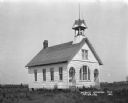
| Date: | 1921 |
|---|---|
| Description: | Exterior of the public schoolhouse, which features a bell tower and two arched entrances. |

| Date: | 1925 |
|---|---|
| Description: | Elevated view of Mount Vernon from the a grassy hill. |

| Date: | 1858 |
|---|---|
| Description: | An ink on paper map of Milwaukee County and the eastern portion of Waukesha County that shows the townships of Oak Creek, Franklin, Greenfield, Wauwatosa, ... |

| Date: | 10 19 1836 |
|---|---|
| Description: | This 1836 manuscript map shows the sections, windfalls, marshes, streams, prairies, acreages, and former mouth of the Pike River in what is now the eastern... |

| Date: | 1974 |
|---|---|
| Description: | This 1974 map is a reproduction of the original survey maps of the Four Lakes region of Dane County, Wisconsin. It shows sections, lakes, rivers, wetlands,... |
| Date: | 1922 |
|---|---|
| Description: | This early 20th century manuscript map shows prairie, maple, maple and beech, marsh conifer, oak, oak and maple, and grass and sedge areas by town in Dodge... |

| Date: | 1840 |
|---|---|
| Description: | This manuscript map by Increase Lapham shows the railroads, roads, wetlands, lakes and streams, dams, prairies, and settlers in the eastern half of Waukesh... |

| Date: | 1836 |
|---|---|
| Description: | Map shows rivers, creeks, roads, trails, mills, and town of Madison. Includes significant manuscript annotations; Sheet 1 is watercolor on lithographed map... |

| Date: | 1873 |
|---|---|
| Description: | This map shows lots and blocks, additions and subdivisions, and large-scale landownership. The map is oriented with north to the upper right. The map is fr... |

| Date: | 01 25 1959 |
|---|---|
| Description: | Winter scene with brothers Greg and Mark Hennen of 5709 Midmoor Road standing in their snow fort and holding snowballs at the ready the day following a fiv... |

| Date: | 1832 |
|---|---|
| Description: | This map shows lot and block numbers, as well as the location of a shot tower, houses, stores, and barns. The map is oriented with the north to the left. T... |
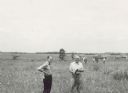
| Date: | 06 1957 |
|---|---|
| Description: | Members of the Board for the Preservation of Scientific Areas inspect the Scuppernong Prairie Scientific Area. The Board furnished this photograph for the ... |

| Date: | 1838 |
|---|---|
| Description: | This map is a development plat that shows street names, numbered blocks and lots, and small farm lot owners. Included on the right of the map is a large am... |

| Date: | 1986 |
|---|---|
| Description: | Nuclear Missile Silo Vigil & Requiem. Hundreds of people surround the fence, holding hands, in opposition to the new MX missiles being installed, missiles ... |
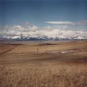
| Date: | 1986 |
|---|---|
| Description: | View across valley towards missile silo, Minuteman F-8. In the foreground is prairie, in the far background are snow-capped mountains and foothills. This... |
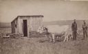
| Date: | 1885 |
|---|---|
| Description: | Team of oxen in front of a sod shanty on the Dakota plains. Two men stand behind the team on the right. The animals are hitched to a plow. |
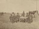
| Date: | 09 1887 |
|---|---|
| Description: | Outdoor group portrait of six men sitting around a table in military uniform in an open field. On the table are pens, an inkwell, two cigar boxes and paper... |

| Date: | 1900 |
|---|---|
| Description: | This map shows portion of the military road from Fond du Lac to the Wisconsin River near Fort Winnebago, with mile markers and adjacent land use. A few pro... |
If you didn't find the material you searched for, our Library Reference Staff can help.
Call our reference desk at 608-264-6535 or email us at: