 Filter: Categories of Wisconsin Historical Images
Filter: Subject of Railroads
Filter: County of Dane
Filter: Community of Madison
Filter: Categories of Wisconsin Historical Images
Filter: Subject of Railroads
Filter: County of Dane
Filter: Community of Madison

| Date: | 02 06 1963 |
|---|---|
| Description: | $25,000 estimated damage was caused when a semi-trailer loaded with Mercedes-Benz engines crashed into a railroad viaduct on Troy Drive near School Road. T... |

| Date: | 03 26 1963 |
|---|---|
| Description: | Daniel Coffey, an Ohio Chemical Company employee, suffered internal head and chest injuries and a fractured right leg when his 1957 Chevrolet was demolishe... |

| Date: | 1880 |
|---|---|
| Description: | This blueprint map shows proposed railroad tracks between Carroll Street and Wisconsin Avenue along Lake Monona. |

| Date: | 1899 |
|---|---|
| Description: | A map of the west part of the city of Madison, including University Heights and the Capitol Square. |

| Date: | 1899 |
|---|---|
| Description: | A map of the east part of the city of Madison, including a portion of the isthmus. |

| Date: | 1907 |
|---|---|
| Description: | This manuscript blueprint map shows land parcels pertaining to University Heights region in Madison, Wisconsin. Streets labeled included, University Avenue... |

| Date: | 1921 |
|---|---|
| Description: | This map, oriented with north to the upper right, shows roads, railroads, and points of interest. Lake Mendota, Wingra, Monona, Waubesa, Mud, Hook, Island,... |

| Date: | 1892 |
|---|---|
| Description: | This map shows pipes of various sizes, hydrants with hydrant pressure, valves, wells, and projected lines. Includes labels for roadways, blocks, wards, par... |

| Date: | 1908 |
|---|---|
| Description: | A Sanborn map featuring the Capitol Square and surrounding business district. |

| Date: | |
|---|---|
| Description: | Aerial view over Monona Bay showing two railroads crossing in the center. Olin Park is on the top left. |

| Date: | 06 1960 |
|---|---|
| Description: | Aerial view looking northwest showing an area to be redeveloped into high-rise dormitories. Lake Mendota and Bascom Woods can be seen at the top. Universit... |

| Date: | 1967 |
|---|---|
| Description: | Air view looking north toward Lake Mendota. The intersection of West Washington Ave. and S. Park Street is at bottom center. The Triangle Redevelopment Pro... |

| Date: | |
|---|---|
| Description: | Aerial view of the Greenbush neighborhood in winter partially demolished for the Triangle Redevelopment Project. Monona Bay and Brittingham park are at rig... |

| Date: | 1890 |
|---|---|
| Description: | Plat map of Madison, T7N R9E, including portions of the towns of Blooming Grove and Burke. Includes inset maps of South Madison, Quarrytown, Marril Park, a... |
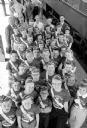
| Date: | 05 01 1957 |
|---|---|
| Description: | Madison Schools students chosen as Safety Patrol members by their schools board the train to Washington, D.C. to attend the National Assembly of School Saf... |

| Date: | 1908 |
|---|---|
| Description: | Bird's-eye view showing Lake Mendota, Lake Monona, Lake Waubesa, Lake Wingra and Lake Kegonsa. Madison has only the isthmus developed, and there are settle... |

| Date: | 1928 |
|---|---|
| Description: | Birds-eye view showing Lake Mendota, Lake Monona, Lake Wingra, Lake Waubesa and Lake Kegonsa. Shows the growth of Madison from the Isthmus along the southe... |

| Date: | 08 01 1957 |
|---|---|
| Description: | North Western Railroad employees attempt to demolish a concrete coal chute at the railroad's East Side yard at Commercial and Sherman Avenues. Groups of me... |

| Date: | 08 01 1957 |
|---|---|
| Description: | North Western Railroad employees attempt to demolish a concrete coal chute at the railroad's East Side yard at Commercial and Sherman Avenue. The first att... |

| Date: | 08 01 1957 |
|---|---|
| Description: | North Western Railroad employees attempt to demolish a concrete coal chute at the railroad's East Side yard at Commercial and Sherman Avenues. After the du... |
If you didn't find the material you searched for, our Library Reference Staff can help.
Call our reference desk at 608-264-6535 or email us at: