 Filter: Categories of Wisconsin Historical Images
Filter: Subject of Railroads
Filter: County of Dane
Filter: Subject of cities and towns
Filter: Categories of Wisconsin Historical Images
Filter: Subject of Railroads
Filter: County of Dane
Filter: Subject of cities and towns

| Date: | 1915 |
|---|---|
| Description: | The Chicago, Milwaukee, and St. Paul Railway freight depot, 40 North Frances Street. Men posing in front of the depot from left to right are: William Dunn... |

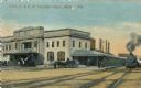
| Date: | 1889 |
|---|---|
| Description: | Chicago, Milwaukee & St. Paul passenger depot with several people standing in front of the building. This is the Franklin Street station on East Wilson Str... |

| Date: | 1889 |
|---|---|
| Description: | Original Chicago & North Western Railroad passenger station, 219 South Blair Street at East Wilson Street, with a few men gathered out front. Torn down in... |

| Date: | 1955 |
|---|---|
| Description: | Chicago and Northwestern Railroad (CN&W) tracks between Brearly and Ingersoll Streets. |
| Date: | 1955 |
|---|---|
| Description: | Chicago and North Western Railroad (CN&W) tracks between Brearly and Ingersoll Streets. |
| Date: | 1910 |
|---|---|
| Description: | The Chicago & Northwestern Railway passenger depot. Caption reads: "C. & N. W. Passenger Depot, Madison, Wis." |
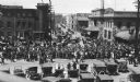
| Date: | 05 25 1918 |
|---|---|
| Description: | A crowd watching as drafted men leave Madison via the Chicago Northwestern railroad station. |

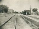
| Date: | 02 08 1970 |
|---|---|
| Description: | Chicago, Milwaukee, St. Paul & Pacific Railroad tracks running down the middle of East Wilson Street from South Baldwin Street to Dickinson Street. |

| Date: | |
|---|---|
| Description: | Exterior view of the Chicago, Milwaukee and St. Paul Railroad depot on the corner of Wilson and Franklin Streets, designed by Edward Townsend Mix. There ar... |

| Date: | 1904 |
|---|---|
| Description: | This map shows a plat of the east part of the city, numbered blocks and lots, some landownership, local streets, roads, railroads, wards by number, parks, ... |
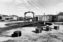
| Date: | 04 27 1975 |
|---|---|
| Description: | A railroad turntable at the Milwaukee Road railroad yard off West Washington Avenue. |

| Date: | 1890 |
|---|---|
| Description: | Left half of a plat map of the "East Part of the city of Madison". |

| Date: | 1890 |
|---|---|
| Description: | Right side of a plat map of the "East Part of the City of Madison". |

| Date: | 1904 |
|---|---|
| Description: | This map shows a plat of the west part of the city, numbered blocks and lots, some landownership, local streets, roads, railroads, wards by number, parks, ... |

| Date: | 1855 |
|---|---|
| Description: | Map of the city of Madison, Dane County, published by George Harrison, surveyed and drawn by P. McCabe, and engraved by J.H. Colton & Co., New York. In add... |
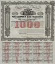
| Date: | 1857 |
|---|---|
| Description: | One thousand dollar bond and coupons issued by the Watertown and Madison Railroad Company in 1857. Jairus Fairchild, president, and T.L. Lawrence have sig... |
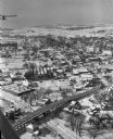
| Date: | 01 22 1949 |
|---|---|
| Description: | Aerial view of the town and the Chicago, Milwaukee, St. Paul and Pacific railroad bridge. |

| Date: | 02 09 1949 |
|---|---|
| Description: | Aerial view of Madison, looking east across the Isthmus including the Wisconsin State Capitol, Lake Mendota, and Lake Monona. |
If you didn't find the material you searched for, our Library Reference Staff can help.
Call our reference desk at 608-264-6535 or email us at:

