 Filter: Categories of Wisconsin Historical Images
Filter: Subject of Railroads
Filter: County of Dane
Filter: Subject of streets
Filter: Categories of Wisconsin Historical Images
Filter: Subject of Railroads
Filter: County of Dane
Filter: Subject of streets

| Date: | 1908 |
|---|---|
| Description: | Colored map showing a panoramic view of Madison in great detail. The Wisconsin State Capitol is located at the center, with Lake Mendota in the background ... |
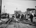
| Date: | 10 27 1936 |
|---|---|
| Description: | Railroad construction crew working on a Chicago & Northwestern Railroad crossing, looking west up the 400 and 500 blocks of East Wilson Street. |
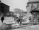
| Date: | 10 27 1936 |
|---|---|
| Description: | Construction crew working on a Chicago & Northwestern Railroad crossing, looking northwest along the 100 block of South Blair Street. |

| Date: | 1942 |
|---|---|
| Description: | Aerial view of Oscar Mayer & Company, 910 Mayer Avenue at Packers Avenue. Shows stock yards, railroad cars and automobile parking lot. Also shows C.E. & P.... |

| Date: | 1855 |
|---|---|
| Description: | Part of George Harrison's "Map of the City of Madison," showing the development of the isthmus and the small size of the second Capitol (54' x 104') in com... |
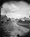
| Date: | 1869 |
|---|---|
| Description: | View from across the railroad track. The Milwaukee and St. Paul Railroad car #4770 is in the foreground. The Freeman House, Carlisle House and Empire Stove... |
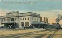
| Date: | 1910 |
|---|---|
| Description: | The Chicago & Northwestern Railway passenger depot. Caption reads: "C. & N. W. Passenger Depot, Madison, Wis." |
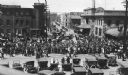
| Date: | 05 25 1918 |
|---|---|
| Description: | A crowd watching as drafted men leave Madison via the Chicago Northwestern railroad station. |

| Date: | 1904 |
|---|---|
| Description: | This map shows a plat of the east part of the city, numbered blocks and lots, some landownership, local streets, roads, railroads, wards by number, parks, ... |

| Date: | 1890 |
|---|---|
| Description: | Left half of a plat map of the "East Part of the city of Madison". |

| Date: | 1890 |
|---|---|
| Description: | Right side of a plat map of the "East Part of the City of Madison". |

| Date: | 1904 |
|---|---|
| Description: | This map shows a plat of the west part of the city, numbered blocks and lots, some landownership, local streets, roads, railroads, wards by number, parks, ... |

| Date: | 1855 |
|---|---|
| Description: | Map of the city of Madison, Dane County, published by George Harrison, surveyed and drawn by P. McCabe, and engraved by J.H. Colton & Co., New York. In add... |

| Date: | 1900 |
|---|---|
| Description: | A hydrographic map of Lake Monona and the adjacent topography. |

| Date: | 1892 |
|---|---|
| Description: | Topographical map of Madison and surrounding communities which include Lake Mendota, Lake Monona, Lake Waubesa and Lake Kegonsa. The red dots on the map sh... |

| Date: | 1953 |
|---|---|
| Description: | A map of Lake Mendota that shows depths and the locations of various species of fish in lake. The maps also identifies a number of selected roads and stree... |

| Date: | 1854 |
|---|---|
| Description: | Shows street grid, sections in adjacent townships, routes of railroads and projected railroads, post offices, and creeks. Table of references identifies ma... |

| Date: | 1917 |
|---|---|
| Description: | Shows property already platted (orange), public property (green), street railway (red lines), Lake Forest development area (red), and some landownership. T... |
If you didn't find the material you searched for, our Library Reference Staff can help.
Call our reference desk at 608-264-6535 or email us at:

