 Filter: Categories of Wisconsin Historical Images
Filter: Subject of Railroads
Filter: Subject of railroads
Filter: County of La Crosse
Filter: Year of 1900-1999
Filter: Categories of Wisconsin Historical Images
Filter: Subject of Railroads
Filter: Subject of railroads
Filter: County of La Crosse
Filter: Year of 1900-1999

| Date: | 1940 |
|---|---|
| Description: | Aerial view of the bridge spanning the Mississippi River in La Crosse. |
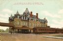
| Date: | 1905 |
|---|---|
| Description: | The Chicago, Milwaukee and St. Paul railroad depot. Caption reads: "C., M. & St. P. R. R. Depot, La Crosse, Wis." |

| Date: | 1911 |
|---|---|
| Description: | Elevated view of the John Gund Brewing Company buildings, with the Mississippi River in the background. Caption reads: "John Gund Brewing Co., La Crosse, W... |
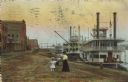
| Date: | 1910 |
|---|---|
| Description: | Caption reads: "Riverfront from Pettibone Park, La Crosse, Wis." There are three steamboats docked on the right in the harbor. A mother and her children ar... |

| Date: | 1900 |
|---|---|
| Description: | A map of La Crosse County, Wisconsin, showing and identifying the townships and section numbers, towns, cities and villages, landowners, rivers, railroads,... |

| Date: | 1931 |
|---|---|
| Description: | Relief shown by contours and spot heights. Maps shows United States, state, county and local highways and roads, schools, North Bend, creeks, lakes, rivers... |

| Date: | 1900 |
|---|---|
| Description: | This map of Bangor is ink and pencil on cloth. The map shows roads, railroads, residences, mills, the original plat of Bangor, and the Wisconsin and Wheldo... |

| Date: | 1954 |
|---|---|
| Description: | This map of La Crosse shows residential, multiple dwelling, local business, commercial, light industrial, heavy industrial and special multiple dwelling la... |

| Date: | 1956 |
|---|---|
| Description: | This map is intended for tourists of La Crosse. The front of the map is text about attractions, activities, and accommodations in La Crosse. The back is th... |

| Date: | 1900 |
|---|---|
| Description: | This map of La Crosse shows twenty wards, some rural lots with acreages, streets, railroads, depots, bridges, cemeteries, parks, schools, islands, and the ... |

| Date: | 1900 |
|---|---|
| Description: | The map is watercolor, pencil, and ink on tracing cloth and shows plats of both cities, local streets, railroads, mills, township divisions, bridges, and p... |

| Date: | 1927 |
|---|---|
| Description: | This map includes an index and highways marked in red. Attractions on the map include: Four Mile House, Cold Springs, Grand Crossing Station, Coleman Sloug... |
If you didn't find the material you searched for, our Library Reference Staff can help.
Call our reference desk at 608-264-6535 or email us at: