 Filter: Categories of Wisconsin Historical Images
Filter: Subject of Railroads
Filter: Subject of railroads
Filter: Subject of forests and forestry
Filter: Categories of Wisconsin Historical Images
Filter: Subject of Railroads
Filter: Subject of railroads
Filter: Subject of forests and forestry
| Date: | |
|---|---|
| Description: | Lumber workers laying railroad tracks through the woods. |
| Date: | 1859 |
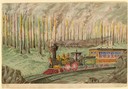
|---|---|
| Description: | The maple and hickory forests in the old northwest were often plagued with fires during the summer months. Hölzlhuber, on a return journey from Niagara Fal... |
| Date: | 1997 |
|---|---|
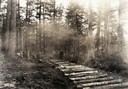
| Description: | Black River State Forest, two miles south of US 54 in the Jackson County Forest. The sand track in the foreground is the grade of the old narrow gauge rail... |
| Date: | 1930 |
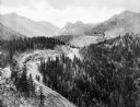
|---|---|
| Description: | Elevated view of the Cripple Creek Short Line Railroad and a train winding through the mountains. |

| Date: | |
|---|---|
| Description: | A postcard with two views functioning as a "before" and "after" of forestry. The view on the left features a man standing in the distance among large trees... |
| Date: | |
|---|---|
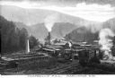
| Description: | Elevated view of Campbell's Mill, which specialized in lumber. Situated in the midst of the forest are smokestacks, railroad tracks, and several buildings.... |
| Date: | |
|---|---|
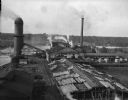
| Description: | Elevated view of the Brooks Scanlon Company, which specialized in lumber. The complex sits on a river. The lumber is lying out on the tops of roofs and in ... |

| Date: | |
|---|---|
| Description: | A railroad bridge crosses over Red Cedar River. |

| Date: | 1939 |
|---|---|
| Description: | This nine-part map from the U.S. Bureau of Public Roads identifies federal and state highways in Wisconsin by pavement type. County, forest, park, and publ... |

| Date: | 1944 |
|---|---|
| Description: | This nine-part map from the U.S. Bureau of Public Roads identifies federal and state highways in Wisconsin by pavement type. County, forest, park, and publ... |

| Date: | 1906 |
|---|---|
| Description: | A hand-colored commercial map of Wisconsin and portions of eastern Minnesota, Iowa, northern Illinois, and the Michigan’s Upper Peninsula. The map shows ra... |

| Date: | |
|---|---|
| Description: | Map of northern Iron County, Wisconsin, shows town sections and railroads in the towns of Saxon, Kimball, and Gurney. It also includes the area of the La P... |

| Date: | 1959 |
|---|---|
| Description: | This map identifies public forest land and industrial forest land as of 1959 in Oneida County, Wisconsin, using a 1930 base map showing the township and ra... |

| Date: | 1940 |
|---|---|
| Description: | This map of Taylor County, Wisconsin, shows the township and range grid, towns, sections, cities and villages, railroads, roads, creameries and cheese fact... |

| Date: | 1960 |
|---|---|
| Description: | This mid-20th century tourist brochure for Bayfield County, Wisconsin, includes a map of the county showing towns, cities and villages, highways and roads,... |

| Date: | 1967 |
|---|---|
| Description: | This tourist brochure for Bayfield County, Wisconsin, from 1967 includes a map of the county showing towns, cities and villages, highways and roads, railro... |

| Date: | 1860 |
|---|---|
| Description: | Map shows meadows, forests, buildings, railroad, and lots south of part of the city of Milwaukee. Relief shown by hachures. Includes list of lot acreages. |

| Date: | 1929 |
|---|---|
| Description: | Elevated view from Signal Point of the Mississippi River, railroad and surrounding forest and wetlands. |

| Date: | |
|---|---|
| Description: | A bird's eye view overlooking the Mississippi River, sand bars, the railroad bridge, surrounding forests and wetlands. |

| Date: | 1971 |
|---|---|
| Description: | A topgraphical map of Cable, Wisconsin showing railroads. |
If you didn't find the material you searched for, our Library Reference Staff can help.
Call our reference desk at 608-264-6535 or email us at: