 Filter: Categories of Wisconsin Historical Images
Filter: Subject of Real estate development
Filter: Subject of transportation
Filter: Categories of Wisconsin Historical Images
Filter: Subject of Real estate development
Filter: Subject of transportation

| Date: | 1898 |
|---|---|
| Description: | University Heights from the Chemistry Building on University Avenue. View includes the University of Wisconsin-Madison football field, on the former site o... |

| Date: | 08 28 1970 |
|---|---|
| Description: | An aerial view of West Towne Shopping Center (now West Towne Mall) at Mineral Point and Gammon Roads. |

| Date: | 06 07 1954 |
|---|---|
| Description: | Aerial view of the Midvale neighborhood under construction showing the intersection of Midvale and Tokay Boulevards near the southwestern city limits of Ma... |

| Date: | 06 07 1954 |
|---|---|
| Description: | Aerial view looking north from near the city's southwestern limits in 1954. Shows text indicating Midvale Boulevard, Odana Road, Tokay Boulevard, Mineral P... |

| Date: | 1955 |
|---|---|
| Description: | Aerial view of Midvale neighborhood under construction near Madison's southwestern city limits. The view is focused on the area bounded by Tokay Boulevard,... |

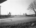
| Date: | 1958 |
|---|---|
| Description: | Aerial view of Craig Avenue and Crestwood Avenue. |
| Date: | 11 23 1938 |
|---|---|
| Description: | A row of houses at 826, 830, 834 & 838 North Fair Oaks Avenue built by the Fitzpatrick Lumber Company in what was the Town of Blooming Grove, now near East... |
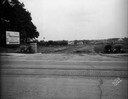
| Date: | 02 26 1930 |
|---|---|
| Description: | Entrance to Westmorland subdivision on Mineral Point Road. |
| Date: | 08 26 1928 |
|---|---|
| Description: | Front view of the entrance to the North Gardens subdivision, on the corner of North Street and Hoard Street, owned by the Paul E. Stark Company. The stone ... |
| Date: | 07 26 1928 |
|---|---|
| Description: | Entrance to the North Gardens subdivision on the corner of North Street and Hoard Street, owned by Paul E. Stark Company. |
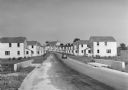
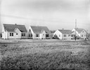
| Date: | 1936 |
|---|---|
| Description: | View down road of mass-produced residential housing with farm in background. |
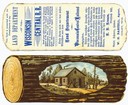
| Date: | |
|---|---|
| Description: | A colored advertising card that was issued by the Land Department of the Wisconsin Central Railroad in order to promote the sale of railroad-owned land in ... |

| Date: | |
|---|---|
| Description: | Poster advertising the Elmside lots for summer homes by Lake Monona. |

| Date: | 1836 |
|---|---|
| Description: | Lots to be sold at auction by Van Antwerp and Van Dyke on Monday, 3rd Oct. 1836. The map shows plots and labeled streets. Iowa County was later split and B... |

| Date: | 1919 |
|---|---|
| Description: | This is a collection of three hand-colored plat maps. One map is a plat plan and includes annotations and an index that shows public land, business, indust... |

| Date: | 12 07 1948 |
|---|---|
| Description: | Houses on the south side of the 2100 block of University Avenue. The address on the entrance at the far right is 2125. |

| Date: | |
|---|---|
| Description: | A man wearing a tie stands next to an industrial trailer used for clearing of land. The side of the trailer reads "BROS" and there are other vehicles in th... |

| Date: | |
|---|---|
| Description: | A man in a hat and overalls leans over a trench or ditch digger, looking down into the excavated area. Pipes, an automobile, and a building are in the back... |
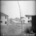
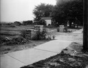
| Date: | 07 05 1938 |
|---|---|
| Description: | A recently planted sapling in the backyard of an empty house, with other houses and roads visible in the background. |
If you didn't find the material you searched for, our Library Reference Staff can help.
Call our reference desk at 608-264-6535 or email us at:
