 Filter: Categories of Wisconsin Historical Images
Filter: Subject of Real estate development
Filter: Year of 1900-1999
Filter: Subject of transportation
Filter: Categories of Wisconsin Historical Images
Filter: Subject of Real estate development
Filter: Year of 1900-1999
Filter: Subject of transportation

| Date: | 08 28 1970 |
|---|---|
| Description: | An aerial view of West Towne Shopping Center (now West Towne Mall) at Mineral Point and Gammon Roads. |

| Date: | 06 07 1954 |
|---|---|
| Description: | Aerial view of the Midvale neighborhood under construction showing the intersection of Midvale and Tokay Boulevards near the southwestern city limits of Ma... |

| Date: | 06 07 1954 |
|---|---|
| Description: | Aerial view looking north from near the city's southwestern limits in 1954. Shows text indicating Midvale Boulevard, Odana Road, Tokay Boulevard, Mineral P... |

| Date: | 1955 |
|---|---|
| Description: | Aerial view of Midvale neighborhood under construction near Madison's southwestern city limits. The view is focused on the area bounded by Tokay Boulevard,... |

| Date: | 1958 |
|---|---|
| Description: | Aerial view of Craig Avenue and Crestwood Avenue. |
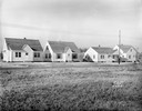
| Date: | 11 23 1938 |
|---|---|
| Description: | A row of houses at 826, 830, 834 & 838 North Fair Oaks Avenue built by the Fitzpatrick Lumber Company in what was the Town of Blooming Grove, now near East... |
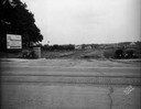
| Date: | 02 26 1930 |
|---|---|
| Description: | Entrance to Westmorland subdivision on Mineral Point Road. |
| Date: | 08 26 1928 |
|---|---|
| Description: | Front view of the entrance to the North Gardens subdivision, on the corner of North Street and Hoard Street, owned by the Paul E. Stark Company. The stone ... |
| Date: | 07 26 1928 |
|---|---|
| Description: | Entrance to the North Gardens subdivision on the corner of North Street and Hoard Street, owned by Paul E. Stark Company. |
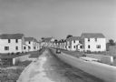
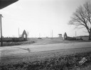
| Date: | 1936 |
|---|---|
| Description: | View down road of mass-produced residential housing with farm in background. |

| Date: | 1919 |
|---|---|
| Description: | This is a collection of three hand-colored plat maps. One map is a plat plan and includes annotations and an index that shows public land, business, indust... |

| Date: | 12 07 1948 |
|---|---|
| Description: | Houses on the south side of the 2100 block of University Avenue. The address on the entrance at the far right is 2125. |
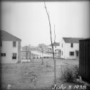
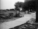
| Date: | 07 05 1938 |
|---|---|
| Description: | A recently planted sapling in the backyard of an empty house, with other houses and roads visible in the background. |
| Date: | 1936 |
|---|---|
| Description: | View from lawn of curved residential street lined with recently constructed housing and lampposts. A car sits in a driveway of a house on the left, and fur... |

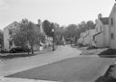
| Date: | 1936 |
|---|---|
| Description: | View up residential street with newly constructed houses, young trees and lampposts. Men in suits and hats walk along the sidewalk. A speed limit sign is o... |

| Date: | 07 15 1957 |
|---|---|
| Description: | Cars park in a new parking lot at the former site of Washington School at 217 North Broom Street. |

| Date: | 1939 |
|---|---|
| Description: | This is a zoning map of Wauwatosa with a key of districts including agricultural, resident, business, commercial, and industrial. The map features labeled ... |

| Date: | 01 31 1964 |
|---|---|
| Description: | Aerial view of University Hill Farms area which has grown from a cow pasture to a square-mile housing and business area. 4,000 people live in 750 single-fa... |

| Date: | 1900 |
|---|---|
| Description: | This photostat map was probably originally created in 1835 and shows in addition to private claims, mills, roads, and trails. Green Bay and the Fox River a... |
If you didn't find the material you searched for, our Library Reference Staff can help.
Call our reference desk at 608-264-6535 or email us at:
