Filter: Categories of Wisconsin Historical Images
Filter: Subject of Rivers
Filter: Year of 1900-1999
Filter: Type of Map or Atlas
Filter: Year of 1960-1969
Filter: Categories of Wisconsin Historical Images
Filter: Subject of Rivers
Filter: Year of 1900-1999
Filter: Type of Map or Atlas
Filter: Year of 1960-1969

| Date: | 1968 |
|---|---|
| Description: | This map shows lakes, rivers and soil types. Lake Michigan, Lake Superior, and portions of Illinois, Iowa, Michigan, and Minnesota are labeled. A legend to... |

| Date: | 1969 |
|---|---|
| Description: | This Post Office Department map identifies post offices, summer post offices, rural stations, highway post offices, Post Office sectional centers, rural de... |

| Date: | 1965 |
|---|---|
| Description: | A map of Milwaukee County showing the county supervisor districts and the city wards. The map also includes the names of those on the on the board of elect... |

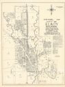
| Date: | 1969 |
|---|---|
| Description: | A map of the Elroy-Sparta State Trail and the surrounding area, showing the townships, the towns of Cashton, Sparta, in the west, and Union Center and Elro... |

| Date: | 1967 |
|---|---|
| Description: | This tourist brochure for Bayfield County, Wisconsin, from 1967 includes a map of the county showing towns, cities and villages, highways and roads, railro... |

| Date: | 1968 |
|---|---|
| Description: | This map is ink and color on printed grid. Shows geology, portage trails, timber type, some landownership, hydrology, and marshes in part of Florence Count... |

| Date: | 1960 |
|---|---|
| Description: | This manuscript map of Taylor County, Wisconsin, shows the township and range grid, lakes and streams, "Chippewa trails, Indian trails" Indian villages and... |

| Date: | 1964 |
|---|---|
| Description: | Shows local streets, bus routes, highways, airport, Dells Pond, Half Moon Lake, Chippewa River, and Eau Claire River. Includes 2 inset maps: Location map a... |
| Date: | 1965 |
|---|---|
| Description: | Shows city limits, plat of town, local streets, railroads, and Baraboo River. "Revised by Mid-State Associates, Baraboo, Wisconsin, April 6, 1965" Upper ri... |

| Date: | 1960 |
|---|---|
| Description: | Color coded map in pink, yellow, blue, and brown of Milwaukee County State and County trunk highways. The map includes a legend of symbols: "STEAM RAIL ROA... |

| Date: | 1965 |
|---|---|
| Description: | Map shows original plat, plat additions, and lot measurements for Rothschild, Wisconsin. Lake Wausau and the Wisconsin River are labelled. Map reads: "Comp... |

| Date: | 1969 |
|---|---|
| Description: | Map showing St. Croix Falls and Taylors Falls, Minnesota. The map was produced by the St. Croix Falls Chamber of Commerce and Taylor Falls Commercial Club.... |

| Date: | 1964 |
|---|---|
| Description: | A simple map of the Mississippi Project. There are symbols at the bottom marking locations for: Voter Registration, Freedom School, Community Center and Pr... |

| Date: | 1964 |
|---|---|
| Description: | This map of Two Rivers shows the Rodgers street fishing area and land use. The map features a legend on the right of the types of land use. The map also sh... |

| Date: | 1962 |
|---|---|
| Description: | This map shows the voting districts of Waukesha in red ink for the year 1962. The bottom of the map includes an index of streets. |

| Date: | 1961 |
|---|---|
| Description: | This map shows established harbor lines, local streets, railroads, U.S. government channel, and part of Fox River. The map includes a table of reference po... |

| Date: | 1960 |
|---|---|
| Description: | This map shows a plat of the city, wards, lots, local streets, roads, railroads, buildings, parks, and part of Fox River. The map includes tables for plat ... |

| Date: | 1961 |
|---|---|
| Description: | This map shows streets and some points of interest. Kewaunee River and Lake Michigan are both labeled. |

| Date: | 1964 |
|---|---|
| Description: | This map is a hand-colored blue line print and shows 4 residence zones, 2 business zones, 1 light manufacturing zones, schools, and parks. The zones are ou... |
If you didn't find the material you searched for, our Library Reference Staff can help.
Call our reference desk at 608-264-6535 or email us at: