 Filter: Categories of Wisconsin Historical Images
Filter: Subject of Rivers
Filter: Year of 1900-1999
Filter: County of Grant
Filter: Categories of Wisconsin Historical Images
Filter: Subject of Rivers
Filter: Year of 1900-1999
Filter: County of Grant

| Date: | 1947 |
|---|---|
| Description: | The Passenger Pigeon Monument was designed and built around 1947. It was erected by the Wisconsin Society for Ornithology. |

| Date: | 1912 |
|---|---|
| Description: | Sanborn insurance map of the main street in Potosi, Wisconsin, with an inset for the Potosi Brewery. |

| Date: | 04 18 1965 |
|---|---|
| Description: | View of a wooded area affected by a Wisconsin River flood. |
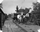
| Date: | 1913 |
|---|---|
| Description: | A man drives a team of horses pulling a wagon across a bridge. The man is standing atop the barreled goods, holding the reins. There is dung on the road. |
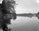
| Date: | 1913 |
|---|---|
| Description: | A view across the river. Trees are along the left shoreline. |

| Date: | 07 1949 |
|---|---|
| Description: | Gothic roofed barn with river scene painted on its roof by Frank Engebretson. |

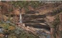
| Date: | 1900 |
|---|---|
| Description: | View from ice-covered river of Dripping Springs along shoreline in winter. |

| Date: | 1972 |
|---|---|
| Description: | Ink on tracing paper. This map shows rivers, Prairie du Chien, site of Fort Crawford, Excelsior, Fort Andrew, Boscobel, Blue River, Orion, Muscoda, Castle ... |

| Date: | 1913 |
|---|---|
| Description: | Photographic postcard along shoreline of a group of people fishing at Rudolph Mill. Sherwin Gillett's wife's cousin, William Schmitt, is standing in the fo... |
| Date: | 1914 |
|---|---|
| Description: | Postcard for Marquette Park in Grant County, number 4706 in a series by E.A. Bishop of Racine. The caption on the back of the postcard reads: "The pictures... |

| Date: | 1969 |
|---|---|
| Description: | This street map was given out by Mound City Bank and features a legend of points of interest and a street index. Streets are labeled as is the Roundtree Br... |

| Date: | 1960 |
|---|---|
| Description: | This street map was likely given out by Mound City Bank and features a legend of points of interest and a street index. Streets are labeled as is the Round... |

| Date: | 04 03 1965 |
|---|---|
| Description: | From back of Pairing, "Flooded land partly covered by ice at Knapp's Creek (at junction with the Wisconsin River near Boscobel), Wis. View looking toward t... |

| Date: | 1906 |
|---|---|
| Description: | This topographical map shows the Little Platte River, shafts, test-pits, old workings, contour lines of Galena limestone elevation, railroads, and building... |

| Date: | 1942 |
|---|---|
| Description: | This map shows a paper city laid out in 1836 on the Wisconsin River, now the site of Wyalusing State Park, Grant County. The upper right corner includes a ... |

| Date: | 1967 |
|---|---|
| Description: | A horse-drawn carriage carrying visitors is coming through a covered bridge at Stonefield Village. |

| Date: | 1918 |
|---|---|
| Description: | Elevated view of Slabtown/Flora Fountain. The church in the lower right was built by the Latter Day Saints and later moved to Lancaster. |
If you didn't find the material you searched for, our Library Reference Staff can help.
Call our reference desk at 608-264-6535 or email us at: