Filter: Categories of Wisconsin Historical Images
Filter: Subject of Rivers
Filter: Year of 1900-1999
Filter: Subject of drawing
Filter: Categories of Wisconsin Historical Images
Filter: Subject of Rivers
Filter: Year of 1900-1999
Filter: Subject of drawing

| Date: | 1955 |
|---|---|
| Description: | Artist's conception of ancient village of Aztalan, fortified with high walls surrounding it. |
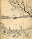
| Date: | 1903 |
|---|---|
| Description: | Drawing of steamboat in the distance on a river (possibly the Wisconsin River). |
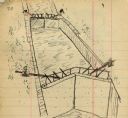
| Date: | 1903 |
|---|---|
| Description: | Lock and dam system on a canal along the Mississippi River. |
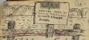
| Date: | 1903 |
|---|---|
| Description: | Sign posted on a fence announcing a lost camera near the town of Prairie du Sac and requesting its return to Herbert Fowler. |

| Date: | 1930 |
|---|---|
| Description: | These 40 hand-drawn maps depict the survey townships in Oneida County, Wisconsin, on printed township grids. Lakes, rivers, and waterfront properties are d... |

| Date: | 1910 |
|---|---|
| Description: | This map is ink on paper. Shows Bruce’s proposed railway route and Moon’s railroad survey route along the Flambeau River, in parts of Lake and Eisenstein t... |
| Date: | 05 06 1973 |
|---|---|
| Description: | Black ink line drawing of a fisherman on the bank of Big Spring Creek near a power house and dam. Puffy clouds fill the sky in the background and thick veg... |

| Date: | 1983 |
|---|---|
| Description: | Imaginative pen-and-ink drawing of three fisherman, Clyde (Bud) Chamberlain with his creel, Stan Hamre, who has fallen backward into the water, and Carl Vo... |
| Date: | 1914 |
|---|---|
| Description: | A map, hand-drawn by Carl Greene, of the McFarland Lake (Minnesota) region. The map also includes several clever, humorous drawings referring to some membe... |

| Date: | 1909 |
|---|---|
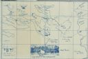
| Description: | A hand-drawn and illustrated map of The Gang's trip from their seventh camp to Lake Superior. |
| Date: | 1919 |
|---|---|
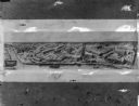
| Description: | Drawing by H.M. Pettit of an aerial view of Deering Works in Chicago. |

| Date: | 03 25 1924 |
|---|---|
| Description: | Drawing by H.M. Pettit of an aerial view of Hamilton Works. |

| Date: | 1900 |
|---|---|
| Description: | A hand-drawn map of the battlefield of the Battle of Chickamauga. |
If you didn't find the material you searched for, our Library Reference Staff can help.
Call our reference desk at 608-264-6535 or email us at: