 Filter: Categories of Wisconsin Historical Images
Filter: Subject of Rivers
Filter: Year of 1900-1999
Filter: Subject of farms
Filter: Categories of Wisconsin Historical Images
Filter: Subject of Rivers
Filter: Year of 1900-1999
Filter: Subject of farms

| Date: | 1943 |
|---|---|
| Description: | This photocopy map shows inhabited farms, rivers, roads, and mills in the vicinity of Marathon City [and village of Edgar], including area between the Big ... |

| Date: | 1919 |
|---|---|
| Description: | This is a collection of three hand-colored plat maps. One map is a plat plan and includes annotations and an index that shows public land, business, indust... |
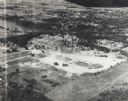
| Date: | 1955 |
|---|---|
| Description: | Aerial view of Valley Fair Mall, with a residential area beyond it on both sides of a river, all surrounded by trees and farmland. |
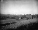
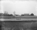
| Date: | 1900 |
|---|---|
| Description: | Rural scene of farmstead with a river or stream (?) in the background. The farm is bounded by a barbed wire fence, and there is a utility pole on the bank ... |

| Date: | 1914 |
|---|---|
| Description: | Slightly elevated view of a man driving three women in an International Model M truck along a rural road. In the background is a valley with farm buildings... |
| Date: | 1920 |
|---|---|
| Description: | A view of a rolling rural landscape, most likely in Sauk County. In the far distance are houses and farm buildings, a church and a larger building, center ... |

| Date: | 1900 |
|---|---|
| Description: | Three men use a McCormick grain binder in a field overlooking a body of water, probably the Saint John River, in Fredericton, New Brunswick, Canada. Men an... |
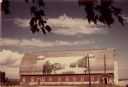
| Date: | 07 1949 |
|---|---|
| Description: | Gothic roofed barn with river scene painted on its roof by Frank Engebretson. |
| Date: | 05 1900 |
|---|---|
| Description: | View of the Herman Backhaus farm buildings from across the Rock River. Four people are sitting in a rowboat. Other people are standing along the shoreline ... |

| Date: | 1934 |
|---|---|
| Description: | This map shows industrial points of interest in Superior. The top of the map reads: "Superior, Douglas County, Wisconsin, as this Industrial Tour map indic... |

| Date: | 1913 |
|---|---|
| Description: | View from riverbank looking down towards two girls standing in the middle of a bridge along a road. They are looking over the railing at the water below. F... |
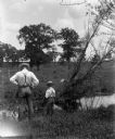
| Date: | 06 1906 |
|---|---|
| Description: | Alexander and Edgar Krueger fishing along a small creek on their farm. Both have their backs to the camera, looking into the water below. |

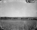
| Date: | 1900 |
|---|---|
| Description: | View from hill looking down towards valley with fields and a river. |

| Date: | 1935 |
|---|---|
| Description: | This map shows railroads, telephone lines, roads, trails, schools, sub-agency, lookout stations, churches, community centers, and school site and farm. Bil... |

| Date: | 1930 |
|---|---|
| Description: | A map of the site of a Native American village with a complex of linear raised garden beds and cache pits near Leeman. Also shown are a farmstead, road, an... |

| Date: | 1907 |
|---|---|
| Description: | Elevated view from hill towards the Fox River, with a farm in the foreground. The farm has a windmill with a sign on it that reads: "Kilbourn Steel Mill," ... |

| Date: | 1921 |
|---|---|
| Description: | View across field towards a bend in the Shullsburg Branch, which runs from the Galena River near the town of Lead Mine to the town of Shullsburg. A farm is... |

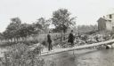
| Date: | 09 01 1919 |
|---|---|
| Description: | Photographic postcard view of a river, with part of an outbuilding in the foreground on the left. On the opposite shoreline is a farm, with farmhouse, barn... |
| Date: | 1909 |
|---|---|
| Description: | View from shoreline towards W.A. Holt and Mr. McDonald, dressed in suits, walking across a fallen tree trunk which serves as a bridge over a river. They ar... |
If you didn't find the material you searched for, our Library Reference Staff can help.
Call our reference desk at 608-264-6535 or email us at:
