 Filter: Categories of Wisconsin Historical Images
Filter: Subject of Rivers
Filter: Year of 1900-1999
Filter: Subject of ponds
Filter: Categories of Wisconsin Historical Images
Filter: Subject of Rivers
Filter: Year of 1900-1999
Filter: Subject of ponds
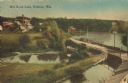
| Date: | 1905 |
|---|---|
| Description: | Elevated view of a pond, a stream, and a lake, with a road dividing the pond and stream from the lake. Industrial buildings and a smokestack are in the bac... |
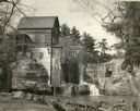
| Date: | 1948 |
|---|---|
| Description: | Abandoned mill, formerly called the Modena Roller Mills. The first mill was built in 1865 (now torn down). |

| Date: | 1900 |
|---|---|
| Description: | Elevated view of parade turning from Nebraska Street onto Main Street. Women with umbrellas line the sidewalk in the foreground of the image. The Montello ... |

| Date: | 1905 |
|---|---|
| Description: | View of the lagoon and surrounding wooded area in Tenney Park. Caption reads: "Lagoon in Tenney Park, Madison, Wis." |

| Date: | 1907 |
|---|---|
| Description: | Bridge and Lagoon in Tenney Park. Caption reads: "Bridge and Lagoon, Tenney Park, Madison, Wisconsin." |

| Date: | 1900 |
|---|---|
| Description: | A man leads two horses pulling a McCormick automatic self-rake reaper through a field while another man follows behind. In the background is a river or pon... |

| Date: | 1900 |
|---|---|
| Description: | This map of Bangor is ink and pencil on cloth. The map shows roads, railroads, residences, mills, the original plat of Bangor, and the Wisconsin and Wheldo... |

| Date: | 1910 |
|---|---|
| Description: | Elevated view over the ox-bow of the Bark River in early morning. Buildings, dwellings and barns are in the foreground at the bottom of the hill, and a bri... |

| Date: | 1961 |
|---|---|
| Description: | Slightly elevated three-quarter view from front of driver's side of Scout. The Scout has a large truck bed topper that rises higher than the cab roof. A ma... |

| Date: | 1909 |
|---|---|
| Description: | View across river toward the mill and dam. Caption reads: "Glen Lock Dam and Mill, Chippewa Falls, Wis." |
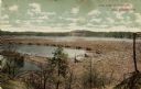
| Date: | 1910 |
|---|---|
| Description: | A colored photographic postcard view of a large log jam in the Dells Pond at Eau Claire. There are "booms" and several men standing on logs. Caption reads:... |

| Date: | 1959 |
|---|---|
| Description: | This map shows some land ownership, lot and block numbers, additions, fair grounds, streets, and railroads and is indexed. Mullet River and Mill Pond are l... |

| Date: | 1937 |
|---|---|
| Description: | This is map 1 from a set of 4 taken from an atlas. The map shows streets, neighborhoods and proposed subdivision. Lake Michigan, Algoma Outer Harbor, the A... |

| Date: | 1912 |
|---|---|
| Description: | Marinette County, Township 36 N., Range 20 E. |

| Date: | 1912 |
|---|---|
| Description: | Marinette County, Fract. Township 37 N., Ranges 21 and 22 E. |

| Date: | 1900 |
|---|---|
| Description: | This map shows logging roads, railroads with spur lines, trails, rapids, lumber camps, Indian villages, summer resort, lakes, rivers, and ponds. |

| Date: | 1910 |
|---|---|
| Description: | This set of manuscript blueprint maps show block and lot numbers, railroads, and some landownership, including lands and buildings of J.S. Owen Lumber Co. ... |

| Date: | 06 1957 |
|---|---|
| Description: | View of Sid fishing in tall grass at a pond or river. He is looking over his shoulder towards the camera. |

| Date: | 1931 |
|---|---|
| Description: | A plat map of Springfield, Wisconsin. |
If you didn't find the material you searched for, our Library Reference Staff can help.
Call our reference desk at 608-264-6535 or email us at:
