 Filter: Categories of Wisconsin Historical Images
Filter: Subject of Rivers
Filter: Year of 1900-1999
Filter: Subject of streams
Filter: Categories of Wisconsin Historical Images
Filter: Subject of Rivers
Filter: Year of 1900-1999
Filter: Subject of streams

| Date: | 1936 |
|---|---|
| Description: | This map is red and black ink on tracing cloth and is oriented with north to the upper left. This hand-drawn map shows a central portion of the military ro... |
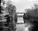
| Date: | 1909 |
|---|---|
| Description: | View from river of Dell Creek bridge with bluff and birch trees on the left. |
| Date: | 1905 |
|---|---|
| Description: | Henry A. Dahl, member of the Menomonie High School class of 1905, depicted as a fisherman. Pictured with a long wooden pole and a straw hat. Part of a year... |
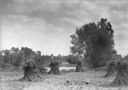
| Date: | 1925 |
|---|---|
| Description: | Corn shocks stand in a field with several pumpkins on the ground. There is a stream or river along the field, and in the background is a bridge over a dam... |

| Date: | 1918 |
|---|---|
| Description: | Map of Wisconsin along with the western portion of Michigan’s Upper Peninsula, showing county lines, cities and villages, lakes, streams, and railroads. Po... |

| Date: | 1917 |
|---|---|
| Description: | A geological survey map of southeastern Wisconsin that shows the configuration of the bedrock beneath the glacial drift and other deposits in southeastern ... |

| Date: | 1917 |
|---|---|
| Description: | A geological survey map that map of southeastern Wisconsin shows the surface deposits east of the Wisconsin River, from the Illinois state line north to Ne... |
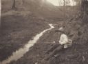
| Date: | 04 1922 |
|---|---|
| Description: | The photographer's wife Clothilde leans on a railing, looking at water rushing through a stone culvert on Fish Creek. Their car is parked on the roadway. A... |

| Date: | 1926 |
|---|---|
| Description: | A topographic map of Green County, showing by contours and spot heights the topographic and natural features of the county. The contour intervals are 20 fe... |

| Date: | 1906 |
|---|---|
| Description: | A map of Berlin, Wisconsin and the surrounding area, showing the old channel of the Fox River and the site of Mascouten village just south of that city in ... |

| Date: | 1931 |
|---|---|
| Description: | A topographical map from the U.S. Army Corp of Engineers showing the topography and man-made features in the Camp Williams area of the towns of Orange and ... |

| Date: | 09 17 1959 |
|---|---|
| Description: | A map of the Menominee Indian Reservation that shows the highways, different types of roads, rivers and streams in the area. |

| Date: | 1976 |
|---|---|
| Description: | An 1876 reprinted map of the Township of Franklin, Milwaukee County, Wisconsin, that shows the land ownership and sectioning of the town, as well as the ro... |
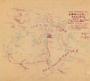
| Date: | 12 1900 |
|---|---|
| Description: | This manuscript map from 1900 shows resorts, lakes, rivers and streams, roads, railroads, and telephone lines in northwest Vilas County, in the towns of Bo... |
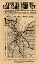
| Date: | 1919 |
|---|---|
| Description: | This flier, likely printed in 1919, promotes the vote for a bond issue to fund "hard roads" in Brown County, Wisconsin. The map shows the 135 miles of conc... |

| Date: | 1941 |
|---|---|
| Description: | This 1941 map covers Washburn County, Wisconsin, as well as western Sawyer, eastern Burnett, and northeastern Polk counties. It shows the locations of tour... |

| Date: | 1936 |
|---|---|
| Description: | This 1936 map of Clark County, Wisconsin, shows the township and range grid, sections, cities and town, and lakes and streams in the county. It lacks the k... |

| Date: | 1902 |
|---|---|
| Description: | This 1902 map of Winnebago County, Wisconsin, shows the township and range grid, towns, sections, cities and villages, landownership and acreages, railroad... |
If you didn't find the material you searched for, our Library Reference Staff can help.
Call our reference desk at 608-264-6535 or email us at:

