 Filter: Categories of Wisconsin Historical Images
Filter: Subject of Rivers
Filter: Year of 1900-1999
Filter: Year of 1910-1919
Filter: Year of 1917
Filter: Categories of Wisconsin Historical Images
Filter: Subject of Rivers
Filter: Year of 1900-1999
Filter: Year of 1910-1919
Filter: Year of 1917
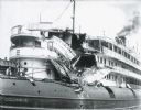
| Date: | 06 30 1917 |
|---|---|
| Description: | Damaged ship on the Milwaukee River. The Christopher Columbus was a popular cruise vessel launched in 1893 and used to traverse the Great Lakes. On ... |
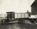
| Date: | 1917 |
|---|---|
| Description: | Man loading ice from loading dock with an International Model F (or 31) truck. The truck was operated by the Hudson/Willow River Ice Company. There is a la... |
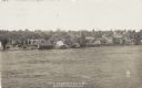
| Date: | 1917 |
|---|---|
| Description: | View looking across the river east into Black River Falls during the flood, showing the elevated level of the river and buildings falling into the water. C... |
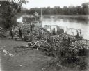
| Date: | 1917 |
|---|---|
| Description: | Elevated view of six men on the shore of a river, with piles of clam shells inside loose wooden fences near a pile of firewood and an axe. The firewood may... |

| Date: | 1917 |
|---|---|
| Description: | Film still of an exterior with a woman; river in the background. |

| Date: | 1917 |
|---|---|
| Description: | A geological survey map that shows the sedimentary and igneous deposits in southeastern Wisconsin and south central Wisconsin, as well as the limits of gla... |

| Date: | 1917 |
|---|---|
| Description: | A geological survey map of southeastern Wisconsin that shows the configuration of the bedrock beneath the glacial drift and other deposits in southeastern ... |

| Date: | 1917 |
|---|---|
| Description: | A geological survey map that map of southeastern Wisconsin shows the surface deposits east of the Wisconsin River, from the Illinois state line north to Ne... |

| Date: | 1917 |
|---|---|
| Description: | Shows property already platted (orange), public property (green), street railway (red lines), Lake Forest development area (red), and some landownership. T... |

| Date: | 1917 |
|---|---|
| Description: | Prototype of a G-9 Caterpillar tank during a demonstration for members of the United States Army at the Los Angeles River. Two men stand on the left. |

| Date: | 1917 |
|---|---|
| Description: | This map shows streets, land owners, local businesses, the St. Louis River, and bridges. The maps reads: "Incorporated 1917." The back of the map includes ... |

| Date: | 1917 |
|---|---|
| Description: | View over the wing of a Lawson Military Tractor 2 (MT2) in flight. Below are houses and what may be a river or lake. Location is unknown, but is probably n... |

| Date: | 1917 |
|---|---|
| Description: | This road map shows routes through the state as well as some portions of Iowa, Minnesota, and Michigan. Cities, the Mississippi River, Lake Winnebago, Gree... |

| Date: | 1917 |
|---|---|
| Description: | View of a road bridge crossing the Menominee River. There is a paper mill on the opposite shoreline. Caption reads: "Hattie Street Bridge and M. & M. Paper... |

| Date: | 07 30 1917 |
|---|---|
| Description: | View across railroad tracks towards a ship, with the name: "Charles Horn, J.O. Nessen Lumber Co." on the side. There are buildings and railroad cars on the... |

| Date: | 1917 |
|---|---|
| Description: | Text on front reads: "Municipal Bathing Beach. Watertown, Wis." Slightly elevated view of a bathing beach on the Rock River. Many swimmers are in the water... |
If you didn't find the material you searched for, our Library Reference Staff can help.
Call our reference desk at 608-264-6535 or email us at: