Filter: Categories of Wisconsin Historical Images
Filter: Subject of Rivers
Filter: Year of 1900-1999
Filter: Year of 1970-1979
Filter: Year of 1972
Filter: Categories of Wisconsin Historical Images
Filter: Subject of Rivers
Filter: Year of 1900-1999
Filter: Year of 1970-1979
Filter: Year of 1972

| Date: | 09 14 1972 |
|---|---|
| Description: | Elevated view of an inland river barge that was purchased by Electro-Motive and used by Wisconsin Barge Lines. Original Falk caption reads, "4.074:1 twin s... |

| Date: | 10 1972 |
|---|---|
| Description: | Gaylord Nelson, Patrick Lucey, and Walter Mondale look over the St. Croix River. In the background a bridge is under construction. |

| Date: | 1972 |
|---|---|
| Description: | Political scientist Samuel L. Popkin and his wife. This photograph was taken about the time Wisconsin-born Popkin was jailed for his refusal to testify abo... |

| Date: | 1972 |
|---|---|
| Description: | This map on 5 sheets features a title page sheet with business directory and shows section numbers, roads, railroads, saw mills, churches, blacksmith shops... |

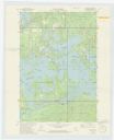
| Date: | 1972 |
|---|---|
| Description: | Ink on tracing paper. This map shows rivers, Prairie du Chien, site of Fort Crawford, Excelsior, Fort Andrew, Boscobel, Blue River, Orion, Muscoda, Castle ... |
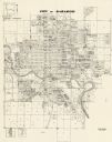
| Date: | 1972 |
|---|---|
| Description: | This map shows plat of the city, city limits, local streets, and part of the Baraboo River. The map includes 3 inset maps. |

| Date: | 1972 |
|---|---|
| Description: | Imaginative pen-and-ink drawing of a view from across a stream towards a cigar-smoking fisherman (probably Sid Boyum) on the opposite side of the bank. He ... |
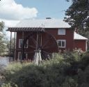
| Date: | 08 1972 |
|---|---|
| Description: | View along shoreline towards a red mill building with a wood waterwheel on a river. |

| Date: | 05 1972 |
|---|---|
| Description: | Close-up view of a rainbow trout making a splash while fighting a fishing line on the Pine River. |
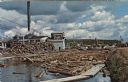
| Date: | 1972 |
|---|---|
| Description: | View of a log jam on the Wolf River next to a saw mill. Caption on back reads: "first built in 1908 . . . 20,000,000 feet lumber cut a year . . . largest i... |
If you didn't find the material you searched for, our Library Reference Staff can help.
Call our reference desk at 608-264-6535 or email us at: