 Filter: Categories of Wisconsin Historical Images
Filter: Subject of Rivers
Filter: Year of 1900-1999
Filter: Year of 1980-1989
Filter: Year of 1985
Filter: Categories of Wisconsin Historical Images
Filter: Subject of Rivers
Filter: Year of 1900-1999
Filter: Year of 1980-1989
Filter: Year of 1985

| Date: | 01 15 1985 |
|---|---|
| Description: | Mecan River bridge on County Highway N over the Mecan River in rural Marquette County. |
| Date: | 1985 |
|---|---|
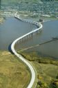
| Description: | Aerial view of the Duluth-Superior Bridge, officially named in honor of Richard I. Bong, World War II's Ace of Aces, who hailed from nearby Poplar, Wiscons... |

| Date: | 1985 |
|---|---|
| Description: | This map shows mining, White River, Silver Creek, Bad River, Agogic Lake, Chequamegon Bay, smaller lakes, the Bad River Indian Reservation, and communities... |
| Date: | 1985 |
|---|---|
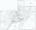
| Description: | This photocopied map shows the area as it appeared in 1889. The map shows buildings, lot numbers, some landownership, and the Fox River. |
If you didn't find the material you searched for, our Library Reference Staff can help.
Call our reference desk at 608-264-6535 or email us at: