Filter: Categories of Wisconsin Historical Images
Filter: Subject of Roads
Filter: County of Dane
Filter: Subject of cities and towns
Filter: Categories of Wisconsin Historical Images
Filter: Subject of Roads
Filter: County of Dane
Filter: Subject of cities and towns

| Date: | 1904 |
|---|---|
| Description: | This map shows a plat of the east part of the city, numbered blocks and lots, some landownership, local streets, roads, railroads, wards by number, parks, ... |

| Date: | |
|---|---|
| Description: | The intersection of Gilman Street and Wisconsin Avenue, in winter. |

| Date: | |
|---|---|
| Description: | Elevated panoramic view of the Gisholt Machine Company, 1245 East Washington Avenue. |

| Date: | |
|---|---|
| Description: | Exterior view of the Fess Hotel at 123 East Doty Street, next to Badger Furniture. |

| Date: | 1856 |
|---|---|
| Description: | Isthmus of Madison, including Lake Mendota, or Great Lake, and Lake Menona [sic]. |

| Date: | |
|---|---|
| Description: | Aerial view of the southeast, with West Broadway and the South Beltline running through the image. Also shows Nob Hill restaurant, the Toki family farm and... |

| Date: | 1904 |
|---|---|
| Description: | This map shows a plat of the west part of the city, numbered blocks and lots, some landownership, local streets, roads, railroads, wards by number, parks, ... |

| Date: | 09 28 1940 |
|---|---|
| Description: | West Johnson Street at the intersection of North Henry Street. |
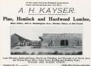
| Date: | 1901 |
|---|---|
| Description: | An advertisement for the A.H. Kayser lumberyard at 204 East Washington Avenue. |

| Date: | 04 1937 |
|---|---|
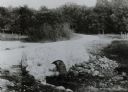
| Description: | From back of print: "Dane County, Town of Middleton, north 1/2 section of section 17 looking SW from a hill across the valley showing erosion and stump pas... |
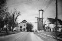
| Date: | 1940 |
|---|---|
| Description: | View down a street in Sun Prairie, including a home, watertower, and church. |

| Date: | |
|---|---|
| Description: | View down unpaved Madison Avenue, lined with trees on either side. Caption reads: "Madison Ave., Sun Prairie Wis". |

| Date: | 1855 |
|---|---|
| Description: | Map of the city of Madison, Dane County, published by George Harrison, surveyed and drawn by P. McCabe, and engraved by J.H. Colton & Co., New York. In add... |

| Date: | 1880 |
|---|---|
| Description: | Elevated exterior view of the Isham & Hale Store, with bolts of cloth displayed outside. |
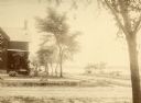
| Date: | 1875 |
|---|---|
| Description: | Exterior view of the Giles house, residence of Hiram H. Giles, state legislator and social welfare authority. |
If you didn't find the material you searched for, our Library Reference Staff can help.
Call our reference desk at 608-264-6535 or email us at: