 Filter: Categories of Wisconsin Historical Images
Filter: Subject of Roads
Filter: County of Dane
Filter: Year of 1800-1899
Filter: Year of 1850-1859
Filter: Categories of Wisconsin Historical Images
Filter: Subject of Roads
Filter: County of Dane
Filter: Year of 1800-1899
Filter: Year of 1850-1859
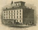
| Date: | 1853 |
|---|---|
| Description: | Illustration of the Capital house, a first-class hotel, copied from page 320 of Gleason's Pictorial Drawing-Room Companion. |

| Date: | 1852 |
|---|---|
| Description: | Pencil drawing of Madison landscape as seen from University Hill. The main street in the center is State Street, and the building with Greek columns in the... |

| Date: | 1852 |
|---|---|
| Description: | Pencil drawing of view overlooking Madison. The sketch looks down North Hamilton Street from the capitol. Rutted, irregular streets and frame houses mark ... |
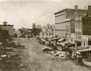
| Date: | 1859 |
|---|---|
| Description: | Daguerreotype of elevated view of Pinckney Street, looking northwest. View includes the American House and Bruen's Block, both on the corner of East Washin... |

| Date: | 1857 |
|---|---|
| Description: | Bird's-eye view of Madison over rooftop and across lake with sailboats and steamers. A group of people are standing on a viewing platform on the roof in th... |

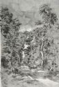
| Date: | 08 1852 |
|---|---|
| Description: | Pencil drawing of a dirt road through the woods with added white highlights. A horse-drawn wagon with two passengers moves down the road in the distance, ... |

| Date: | 1856 |
|---|---|
| Description: | Isthmus of Madison, including Lake Mendota, or Great Lake, and Lake Menona [sic]. |

| Date: | 1855 |
|---|---|
| Description: | Map of the city of Madison, Dane County, published by George Harrison, surveyed and drawn by P. McCabe, and engraved by J.H. Colton & Co., New York. In add... |

| Date: | 1854 |
|---|---|
| Description: | This mid-19th century map of Dane County, Wisconsin, shows the township and range grid, towns, sections, cities, villages and post offices, lakes and strea... |
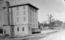
| Date: | 1850 |
|---|---|
| Description: | A grist mill on the Yahara River at the outlet of Lake Mendota. The mill, called Farwell's Madison Mills was built in 1850 by Governor Farwell. The origina... |
| Date: | 1852 |
|---|---|
| Description: | View down a road lined with trees. Two people in a horse-drawn vehicle are moving down the road. Caption reads: "Unidientified road in the vicinity of Madi... |
If you didn't find the material you searched for, our Library Reference Staff can help.
Call our reference desk at 608-264-6535 or email us at: