 Filter: Categories of Wisconsin Historical Images
Filter: Subject of Roads
Filter: County of Dane
Filter: Year of 1800-1899
Filter: Year of 1860-1869
Filter: Categories of Wisconsin Historical Images
Filter: Subject of Roads
Filter: County of Dane
Filter: Year of 1800-1899
Filter: Year of 1860-1869

| Date: | 1861 |
|---|---|
| Description: | View of Madison from Main Hall, now Bascom Hall, on the University of Wisconsin-Madison campus looking up State Street toward the second Wisconsin State Ca... |

| Date: | 1867 |
|---|---|
| Description: | Bird's-eye map of Madison with insets of the University, Rasdall House, Vilas House, and the Wisconsin State Capitol. View includes cattail marsh, smokesta... |
| Date: | 1865 |
|---|---|
| Description: | South Wisconsin Avenue and West Main Street. Lake Monona is in the background and the Lucius Fairchild and David Atwood houses are at the upper left. The r... |
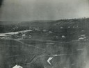
| Date: | 1860 |
|---|---|
| Description: | Elevated view of multiple buildings in Cross Plains from Lutheran Church Hill. Many roads and fences cross the fields. Wooded hills are in the background. ... |
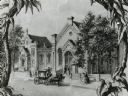
| Date: | 1864 |
|---|---|
| Description: | Early drawing of the Gates of Heaven Synagogue (on the left) and the Congregational Church (on the right), located on the 200 block of West Washington Aven... |
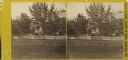
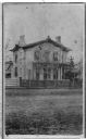
| Date: | 1868 |
|---|---|
| Description: | Stereograph of the Rublee house, among trees. The residence of Horace Rublee, formerly owned by J.A Ellis, on the east corner of Wisconsin Avenue and Gilma... |

| Date: | 1867 |
|---|---|
| Description: | This 1867 manuscript map by Increase Lapham shows the topography and geology of the Blue Mounds region in the Town of Brigham in Iowa County and the towns ... |
| Date: | 1866 |
|---|---|
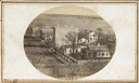
| Description: | Carte-de-visite of local merchant Thaddeus Dean's residence, located at the intersection of Wisconsin Avenue and Gorham Street. |

| Date: | 1861 |
|---|---|
| Description: | The township of Primrose, which is a detail from the plat map of Dane County. |

| Date: | 1861 |
|---|---|
| Description: | The township of Montrose, which is a detail from a Dane County plat map. |
If you didn't find the material you searched for, our Library Reference Staff can help.
Call our reference desk at 608-264-6535 or email us at: