 Filter: Categories of Wisconsin Historical Images
Filter: Subject of Roads
Filter: County of Dane
Filter: Categories of Wisconsin Historical Images
Filter: Subject of Roads
Filter: County of Dane

| Date: | 08 28 1970 |
|---|---|
| Description: | An aerial view of West Towne Shopping Center (now West Towne Mall) at Mineral Point and Gammon Roads. |

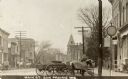
| Date: | 1906 |
|---|---|
| Description: | State Street with torn up streetcar lines, looking east from Park Street. |
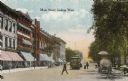
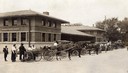
| Date: | 1900 |
|---|---|
| Description: | View down Main Street on the Capitol Square. Caption reads: "Main Street, looking West." |
| Date: | 1934 |
|---|---|
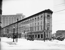
| Description: | Exterior view of the Sherlock Hotel, 124 King Street at the corner of Doty Street. Snow is on the ground. |
| Date: | 11 13 1933 |
|---|---|
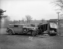
| Description: | Frank Lloyd Wright's 1929 L29 Cord Phaeton automobile and an overturned Choles Floral Company delivery truck, driven by Frost Choles, at an accident scene ... |
| Date: | 02 05 1930 |
|---|---|
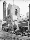
| Description: | View from across the street of the Capitol Theatre tower. "Love Parade" is advertised on the marquee. Three automobiles are in the street in front of Peopl... |

| Date: | 1908 |
|---|---|
| Description: | A panoramic aerial view of the Isthmus taken from a kite. Lake Mendota is to the right in the background with Picnic Point jutting into the lake. The photo... |
| Date: | 1917 |
|---|---|
| Description: | Exterior view of the Municipal Market, which was built in 1910 but not operated successfully until July 1917 when it was run by a group of women from the D... |
| Date: | 1900 |
|---|---|
| Description: | A view down Main Street with horses and wagons tied at hitching posts. |

| Date: | 06 07 1954 |
|---|---|
| Description: | Aerial view of the Midvale neighborhood under construction showing the intersection of Midvale and Tokay Boulevards near the southwestern city limits of Ma... |

| Date: | 06 07 1954 |
|---|---|
| Description: | Aerial view looking north from near the city's southwestern limits in 1954. Shows text indicating Midvale Boulevard, Odana Road, Tokay Boulevard, Mineral P... |

| Date: | 1955 |
|---|---|
| Description: | Aerial view of Midvale neighborhood under construction near Madison's southwestern city limits. The view is focused on the area bounded by Tokay Boulevard,... |
| Date: | 08 07 1929 |
|---|---|
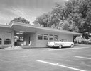
| Description: | Bondi & Sachtjen Texaco service station, 1462 E. Washington Avenue at Thornton Avenue, with Fuller & Johnson buildings in the background. Text with print r... |
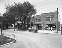
| Date: | 06 14 1927 |
|---|---|
| Description: | Storefronts of the Wisconsin School of Music, East Side Variety Store and Hess Grocery Market. Owned by the Hess family, this property was located at 154 A... |
| Date: | 1958 |
|---|---|
| Description: | 2700 Marshall Court, Doctor's Park, Shorewood Hills. |

| Date: | 1958 |
|---|---|
| Description: | Aerial view of Craig Avenue and Crestwood Avenue. |

| Date: | 1873 |
|---|---|
| Description: | Map of the township of Windsor, from the "Atlas of Dane County." |
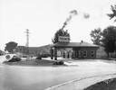
| Date: | 09 30 1933 |
|---|---|
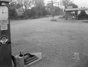
| Description: | Gas station in a Trachte building on the corner of Highway 51 (Monona Drive) and Highway 30 (Cottage Grove Road). A "Johnson Winged 70 Gasoline" pump is in... |
| Date: | 09 30 1933 |
|---|---|
| Description: | A gas station in a Trachte building on the corner of Highway 51 (Monona Drive) and Highway 30 (Cottage Grove Road). "Johnson Gasoline," and "Defiance Spark... |
If you didn't find the material you searched for, our Library Reference Staff can help.
Call our reference desk at 608-264-6535 or email us at:
