 Filter: Categories of Wisconsin Historical Images
Filter: Subject of Roads
Filter: Subject of botany
Filter: Categories of Wisconsin Historical Images
Filter: Subject of Roads
Filter: Subject of botany

| Date: | 1885 |
|---|---|
| Description: | Bird's-eye map of Waupun on the Rock River. There is an inset at top center of "Althouse, Wheeler & Co., Windmills and Pumps." |

| Date: | 1871 |
|---|---|
| Description: | Birds eye map of Brodhead, WI depicts street names and street locations, houses, and trees. A reference key at the bottom of the map shows the locations of... |

| Date: | 1882 |
|---|---|
| Description: | This map of Cedarburg is a bird's-eye map with an inset of Cedarburg Brewery. Relief is shown pictorially and the map includes an index to buildings. |

| Date: | 1896 |
|---|---|
| Description: | Bird's-eye map of Darlington. Area bordered by Washington and North Streets, upper left hand corner, the fairgrounds, upper right corner, River Street, bot... |

| Date: | 1872 |
|---|---|
| Description: | Birds-eye drawing of Eau Claire depicts street names and street locations, houses, trees, bridges, piers, canals, railroads, and the Chippewa and Eau Clair... |

| Date: | 1879 |
|---|---|
| Description: | Bird's-eye map of Lake Mills. |

| Date: | 1883 |
|---|---|
| Description: | Bird's-eye map of Marshfield, with one vignette. |

| Date: | 1875 |
|---|---|
| Description: | Bird's-eye map of Mazomanie. |
| Date: | 10 02 1945 |
|---|---|
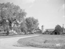
| Description: | Earl Sloan farm near Madison taken for the Wisconsin Power & Light Company. |
| Date: | 10 02 1945 |
|---|---|
| Description: | Ray Haupt farm near Madison, taken for Wisconsin Power & Light. |
| Date: | 04 01 1945 |
|---|---|
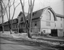
| Description: | Kleinheinz Hall (old Sheep Barn) at 1815 Linden Drive on University of Wisconsin campus. |
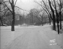
| Date: | 01 19 1945 |
|---|---|
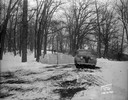
| Description: | Winter scene with automobile parked in front of barricade at west end of Edgewood Drive. |
| Date: | 01 19 1945 |
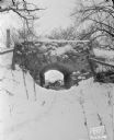
|---|---|
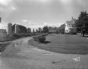
| Description: | Looking towards the stone bridge on Edgewood Drive. |
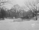
| Date: | 01 19 1945 |
|---|---|
| Description: | Barricades at the east end of Edgewood Drive. |
| Date: | 01 19 1945 |
|---|---|
| Description: | Close-up of barricades at the east end of Edgewood Drive. |
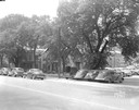
| Date: | 06 20 1944 |
|---|---|
| Description: | Cars parked in the 200 block of West Washington Avenue. Properties shown are, right to left, Fiore Filling Station parking lot, U.S. Government warehouse (... |
If you didn't find the material you searched for, our Library Reference Staff can help.
Call our reference desk at 608-264-6535 or email us at:


