 Filter: Categories of Wisconsin Historical Images
Filter: Subject of Schools
Filter: Subject of rivers
Filter: Categories of Wisconsin Historical Images
Filter: Subject of Schools
Filter: Subject of rivers

| Date: | 1867 |
|---|---|
| Description: | Birds-eye drawing of Beaver Dam, Dodge Co., depicting street names and street layout, houses, rivers, lakes, and trees. A reference key at the bottom of th... |

| Date: | 1890 |
|---|---|
| Description: | Bird's-eye map of Beloit with insets of Williams Engine Works, Eclipse Wind Engine Co., and John Foster & Co. Turtle Creek is in the lower section, and the... |

| Date: | 1867 |
|---|---|
| Description: | Bird's-eye map of Berlin, with insets of West Side Public School and High School. |

| Date: | 1869 |
|---|---|
| Description: | Birds-eye drawing of Boscobel, Grant County, depicts street names and street layouts, houses, rivers and trees. A reference key at the bottom of the map sh... |

| Date: | 1867 |
|---|---|
| Description: | Bird's-eye map of Green Bay and Fort Howard, Brown Co., depicts street names and street layouts, houses, trees, and the East River. A reference key at the ... |

| Date: | 1872 |
|---|---|
| Description: | Birds-eye drawing of Eau Claire depicts street names and street locations, houses, trees, bridges, piers, canals, railroads, and the Chippewa and Eau Clair... |

| Date: | 1874 |
|---|---|
| Description: | Bird's-eye map of Lodi, with inset of Public School. Includes index of churches and points of interest. |

| Date: | |
|---|---|
| Description: | A group of CIO students, who are attending Highlander Folk School, enjoying a picnic at the nearby Foster Falls picnic area. Dad Horton standing on the lef... |
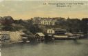
| Date: | 1910 |
|---|---|
| Description: | Elevated view from bridge looking over at a hill leading down to bath houses and fenced-in swimming areas for beginners. Establishment of Wm. Bechstein. Ca... |
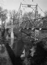
| Date: | |
|---|---|
| Description: | View from top of riverbank along the left side of a steel footbridge over the Sheyenne River leading to the State Normal School Grounds. The sign at the to... |
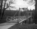
| Date: | |
|---|---|
| Description: | View along right side of a sidewalk to the footbridge over the Sheyenne River leading to the State Normal School Grounds. |

| Date: | |
|---|---|
| Description: | Exterior of Miss Mason's School for Young Ladies, designed by A. J. Davis and completed in 1856. The stone building features a porte cochère, sheltered ent... |

| Date: | 1913 |
|---|---|
| Description: | A wall atlas of Sauk County, Wisconsin, displaying its 22 towns. On the left side are advertisements for local businesses. |

| Date: | 1914 |
|---|---|
| Description: | Plat book of Waukesha County. Pages 14 - 15. |

| Date: | 1939 |
|---|---|
| Description: | This map shows the towns to Gingles, Sanborn, and Guney as well as Chequamegon Bay, Kakagon River, White River, Marengo River, Bad River, Potato River, Vau... |

| Date: | 1880 |
|---|---|
| Description: | A hand-colored map of the Chippewa, Price, Taylor and the northern part of Clark counties, which shows the locations of farmhouses, schoolhouses, churches,... |

| Date: | 1881 |
|---|---|
| Description: | A brochure with a map of Wisconsin that also includes information (in English, German, Norwegian, and Swedish) pertaining to the state, such as its timber ... |
If you didn't find the material you searched for, our Library Reference Staff can help.
Call our reference desk at 608-264-6535 or email us at:


