Filter: Categories of Wisconsin Historical Images
Filter: Subject of Schools
Filter: Subject of roads
Filter: Categories of Wisconsin Historical Images
Filter: Subject of Schools
Filter: Subject of roads

| Date: | 1891 |
|---|---|
| Description: | Bird's-eye map of Wausau, looking north with ninety-eight businesses, industries, churches, schools, and civic buildings identified in location key below i... |

| Date: | 1867 |
|---|---|
| Description: | Birds-eye drawing of Beaver Dam, Dodge Co., depicting street names and street layout, houses, rivers, lakes, and trees. A reference key at the bottom of th... |

| Date: | 1890 |
|---|---|
| Description: | Bird's-eye map of Beloit with insets of Williams Engine Works, Eclipse Wind Engine Co., and John Foster & Co. Turtle Creek is in the lower section, and the... |

| Date: | 1869 |
|---|---|
| Description: | Birds-eye drawing of Boscobel, Grant County, depicts street names and street layouts, houses, rivers and trees. A reference key at the bottom of the map sh... |

| Date: | 1867 |
|---|---|
| Description: | Bird's-eye map of La Crosse with nine insets of residences, schools, and the Court House and Jail. |

| Date: | 1872 |
|---|---|
| Description: | Birds-eye drawing of Eau Claire depicts street names and street locations, houses, trees, bridges, piers, canals, railroads, and the Chippewa and Eau Clair... |

| Date: | 1874 |
|---|---|
| Description: | Bird's-eye map of Lodi, with inset of Public School. Includes index of churches and points of interest. |
| Date: | 06 10 1935 |
|---|---|
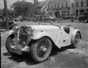
| Description: | Damaged English Singer sports car on the street, E. Washington Avenue, with Brayton School in the background. |

| Date: | 05 02 1964 |
|---|---|
| Description: | Sitting on the school lawn, students draw Highway 51, Marathon Mill, Rib mountain and the Wisconsin River. |

| Date: | 1913 |
|---|---|
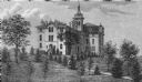
| Description: | The stone and iron gateway entrance to St. Mary's Springs Academy. Caption reads: "Entrance to St. Mary's Springs Academy Fond du Lac, Wis." |
| Date: | 1900 |
|---|---|
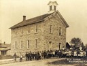
| Description: | The "Rock School" building, with children and teachers posed outside. |

| Date: | 1945 |
|---|---|
| Description: | Aerial view of Taliesin, Frank Lloyd Wright's residence and architectural school complex, with the Wisconsin River visible at the top. Taliesin is located... |

| Date: | 04 17 1945 |
|---|---|
| Description: | The view east down the 1200 block of Williamson Street taken for Continental Casualty. Buildings include the Flesch Grocery, 1209 Williamson Street; Fire ... |

| Date: | 12 12 1945 |
|---|---|
| Description: | Group of five women in class at the Groves-Barnhart School for Secretaries, 502 State Street at Gilman Street. There is a large window in the background, s... |
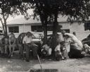
| Date: | |
|---|---|
| Description: | Meeting in Tennessee during CIO period, on a street. |
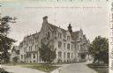
| Date: | 1906 |
|---|---|
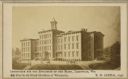
| Description: | Administration building for the school. The building has over three stories, and a covered main entrance. Caption reads: "Administration Building, Industri... |
If you didn't find the material you searched for, our Library Reference Staff can help.
Call our reference desk at 608-264-6535 or email us at: