 Filter: Categories of Wisconsin Historical Images
Filter: Subject of Streets
Filter: County of Dane
Filter: Categories of Wisconsin Historical Images
Filter: Subject of Streets
Filter: County of Dane
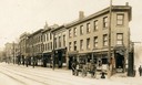
| Date: | 1910 |
|---|---|
| Description: | View across street towards the north side of the 200 block of State Street between Fairchild and Henry Streets. This side was free of saloons. The south si... |

| Date: | 1897 |
|---|---|
| Description: | A view from the capitol looking west up State Street toward the University of Wisconsin-Madison with the Holy Redeemer Church, Holy Redeemer School, Red Gy... |
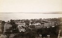
| Date: | 1890 |
|---|---|
| Description: | Looking south from the capitol dome of the Wisconsin State Capitol, the view is of West Main Street bound by South Hamilton Street and Monona Avenue (now M... |
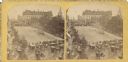
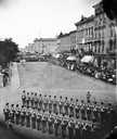
| Date: | 07 04 1876 |
|---|---|
| Description: | Stereograph of view of procession, military company and citizens at Great Centennial Day at the Capitol Square. Scene at Main and Carroll Streets showing t... |
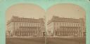
| Date: | 1871 |
|---|---|
| Description: | Exterior view of the Park Hotel. Among its fine features are black walnut trim, Brussels carpet, marble-topped furniture, and spring beds. The hotel was on... |
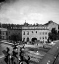
| Date: | 07 1876 |
|---|---|
| Description: | Elevated view from the Park Hotel looking east to the corner of Carroll and Main Streets in Madison. Soldiers are in formation as a part of the centennial ... |
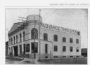
| Date: | 1899 |
|---|---|
| Description: | Exterior view of the Advance Thresher Company, 601 Williamson Street, as seen in "Madison, Wis. And It's Points Of Interest." The dealer was one of many wh... |
| Date: | 1873 |
|---|---|
| Description: | Locomotive, with view east on West Washington Avenue toward the Wisconsin State Capitol. There is a sign near the tracks that reads: "Look Out for The Cars... |
| Date: | 1873 |
|---|---|
| Description: | Elevated view of employees, along with young children, posed around a wagon loaded with barrels of beer in front of Hausmann's Capital Brewery at the corne... |

| Date: | 1836 |
|---|---|
| Description: | The top map is the "Plat of Madison the Capitol of Wisconsin." The bottom map is the "Map of the Four Lake Country. Taken from the Township Maps in the U.S... |

| Date: | 1889 |
|---|---|
| Description: | Illustration of the exterior of the Fuller Opera House, which is a detail from a bird's-eye view map of Madison. |

| Date: | 1910 |
|---|---|
| Description: | Exterior of ice cream parlor with a horse-drawn wagon parked on the right with sheds behind. Barrels are stacked on the porch. Signs above the porch read: ... |

| Date: | 03 02 1946 |
|---|---|
| Description: | Exterior of Frenchy's Restaurant, located at 3302 University Avenue at Shorewood Avenue. |
| Date: | 03 13 1946 |
|---|---|
| Description: | First Unitarian Society Meeting House, 125 Wisconsin Avenue, being razed by Arneson Wrecking Company. View is from Wisconsin Avenue. On the left is the edu... |
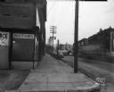
| Date: | 01 08 1946 |
|---|---|
| Description: | View down sidewalk along East Wilson Street at the corner of the South Hancock intersection looking toward the West Wilson Street-King Street intersection.... |
| Date: | 01 08 1946 |
|---|---|
| Description: | East Wilson Street scene looking northeast, taken at site of Reynolds Bus accident. Businesses shown include R & R Cafe at 316 East Wilson Street, Dizon Me... |
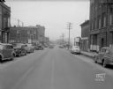
| Date: | 01 08 1946 |
|---|---|
| Description: | East Wilson Street scene at the center of South Hancock Street looking South down South Hancock Street across East Wilson Street, taken at site of Reynolds... |
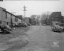
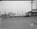
| Date: | 01 08 1946 |
|---|---|
| Description: | South Hancock Street scene looking north uphill across East Wilson Street, taken at site of Reynolds Bus accident. Businesses shown include the Electric Mo... |
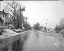
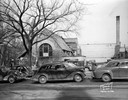
| Date: | 01 09 1946 |
|---|---|
| Description: | Winnebago Street from the Yahara River Bridge, scene of accident, near railroad crossing. There is a Victorian house at left, 1628 Winnebago Street, with a... |
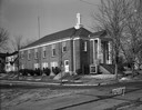
| Date: | 01 14 1946 |
|---|---|
| Description: | Seventh Day Adventist Church, 1124 Colby Street. |
If you didn't find the material you searched for, our Library Reference Staff can help.
Call our reference desk at 608-264-6535 or email us at: