 Filter: Categories of Wisconsin Historical Images
Filter: Subject of Suburbs
Filter: Year of 1900-1999
Filter: Year of 1960-1969
Filter: Categories of Wisconsin Historical Images
Filter: Subject of Suburbs
Filter: Year of 1900-1999
Filter: Year of 1960-1969
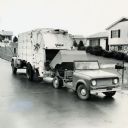
| Date: | 1961 |
|---|---|
| Description: | International Scout truck with dump box loading refuse into a garbage truck in a suburban neighborhood. |
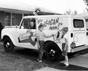
| Date: | 1963 |
|---|---|
| Description: | Two young boys point to an advertising illustration on an International Scout owned and operated by Culligan, Inc. |
| Date: | 07 25 1961 |
|---|---|
| Description: | Propelled by good roads and lower property taxes, many Wisconsin towns became "commuter suburbs" to their larger neighbors during the 1950s and 1960s. Whi... |
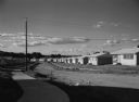
| Date: | 07 03 1960 |
|---|---|
| Description: | View down curving sidewalk of new housing development with a main street of dirt, and box-like, one-story homes. |
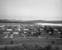
| Date: | 07 24 1966 |
|---|---|
| Description: | Elevated view of small town. A Lake Wisconsin is visible beyond the town limits. |
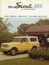
| Date: | 1965 |
|---|---|
| Description: | Cover of an advertising brochure for the International Scout 800, featuring a color photograph of a woman behind the wheel of a Scout truck. There is a you... |

| Date: | 06 08 1960 |
|---|---|
| Description: | Blueprint plat of Sunset Hills sub-division. |
| Date: | 1960 |
|---|---|
| Description: | New residential construction on the outer southwest edge of Madison. |

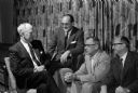
| Date: | 01 14 1960 |
|---|---|
| Description: | Madison Fire Chief Edward Page, center, presents a plaque from the International Fire Chiefs Association to Maple Bluff's volunteer fire department for ach... |
| Date: | 02 23 1960 |
|---|---|
| Description: | Once a year, members of the Shorewood Hills village board and members of the Blackhawk Country Club board of directors get together for a social evening to... |

| Date: | 1966 |
|---|---|
| Description: | This map shows streets, highways, railroads, parks, colleges, cemeteries, county clubs, University of Wisconsin, Truax Field, Middleton, Shorewood Hills, M... |

| Date: | 1969 |
|---|---|
| Description: | This map is pen and ink on paper and shows the location of churches, local streets, railroads, parks, Middleton, Shorewood Hills, Monona, Maple Bluff, McFa... |

| Date: | 1968 |
|---|---|
| Description: | Three maps that show local streets, roads, railroads, parks, country clubs, the University of Wisconsin, Shorewood Hills, Maple Bluff, Monona, Truax Field,... |

| Date: | 1960 |
|---|---|
| Description: | This blue print map shows village limits, collector residential streets, and primary residential streets. The upper right corner features a key to street t... |

| Date: | 1965 |
|---|---|
| Description: | This map is indexed for public buildings and includes a numbered key on the lower left side. The streets are labeled and Lake Michigan is labeled on the fa... |

| Date: | 1965 |
|---|---|
| Description: | This map shows landownership, acreages, and roads. The city of De Pere, the town of Hobart, and the Fox River are labeled. Inset maps showing Smits Subdivi... |

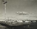
| Date: | 05 1965 |
|---|---|
| Description: | Elevated view from Lake View Sanatorium looking south over Mendota Hills sub-division and Warner Park. |

| Date: | 1966 |
|---|---|
| Description: | This map shows city, suburban, parochial and other types schools, with an explanation of symbols in the right margin. The original caption for the map read... |

| Date: | 1965 |
|---|---|
| Description: | This series of 17 maps show boundaries and changes in city limits from 1846 to 1965. The base of all of the maps are the same, Milwaukee and suburbs. All m... |

| Date: | 1960 |
|---|---|
| Description: | Aerial view of rural landscape with suburban construction in foreground. Cottage Grove Road is at left with the newly constructed Acewood Boulevard crossin... |
If you didn't find the material you searched for, our Library Reference Staff can help.
Call our reference desk at 608-264-6535 or email us at: