Filter: Categories of Wisconsin Historical Images
Filter: Subject of Trails
Filter: Year of 1900-1999
Filter: Reproduction Rights of For Sale
Filter: Categories of Wisconsin Historical Images
Filter: Subject of Trails
Filter: Year of 1900-1999
Filter: Reproduction Rights of For Sale

| Date: | 1968 |
|---|---|
| Description: | This map is ink and color on printed grid. Shows geology, portage trails, timber type, some landownership, hydrology, and marshes in part of Florence Count... |

| Date: | 1960 |
|---|---|
| Description: | This manuscript map of Taylor County, Wisconsin, shows the township and range grid, lakes and streams, "Chippewa trails, Indian trails" Indian villages and... |
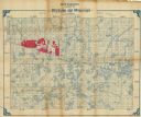
| Date: | 1902 |
|---|---|
| Description: | Shows swamps, lakeside acreages, railroads, trails, and townships in parts of Vilas and Iron Counties, Wisconsin and Gogebic County, Michigan. Relief shown... |

| Date: | 1909 |
|---|---|
| Description: | This 1909 map of northern Wisconsin and a portion of Michigan's Upper Peninsula shows the Lac du Flambeau Indian Reservation, cities and villages, railroad... |

| Date: | 1929 |
|---|---|
| Description: | "Compliments of the Douglas County Highway Department"--Top margin. Shows state-trunk highways, county highways, town roads, trails, boundaries, and concr... |

| Date: | 1953 |
|---|---|
| Description: | "Compliments of the Douglas County Highway Department"--Top margin. Shows federal highways, state trunk highways, county highways, town roads, unimproved ... |

| Date: | 1986 |
|---|---|
| Description: | This late 1980s map of Price County, Wisconsin, shows facilities and lands open for public recreation, hunter walking trails and ski trails, campgrounds, b... |

| Date: | 1975 |
|---|---|
| Description: | This map shows settlers, Indian trails, roads, marshes, and forests as they appeared in 1800-1840. "A bicentennial map of Racine County for the benefit of ... |

| Date: | 1973 |
|---|---|
| Description: | Map shows sections, trails, roads, and locations of ancient burial grounds, hills, groves, and settlers. Printed in brown ink. |

| Date: | 1970 |
|---|---|
| Description: | Map features a legend of roads, trails, points of interest, buildings, and types of vegetation. To the right are "ARBORETUM REGULATIONS" regarding hours, p... |
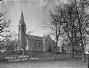
| Date: | 1924 |
|---|---|
| Description: | Side view of the Catholic Church from the bottom of a low hill. Two more buildings are on the left and right behind the church. Bare trees are in the lawn ... |

| Date: | 1974 |
|---|---|
| Description: | A map of Dane County from the Charles Brown Atlas. A hand-drawn blue line marks the Black Hawk Trail. |
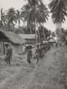
| Date: | 1943 |
|---|---|
| Description: | View down line of indigenous men, from a village near the airstrip, helping soldiers carry equipment to a camp area along a trail. Two soldiers stand off t... |
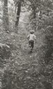
| Date: | 1963 |
|---|---|
| Description: | Young boy, photographed from behind, running along a wooded path. |

| Date: | 1930 |
|---|---|
| Description: | Men, either campers or fishermen, portaging a canoe through backwoods cut-over forest area. |

| Date: | 1930 |
|---|---|
| Description: | Small group of women with a leader in wooded area on a trail engaged in nature study. |

| Date: | 1926 |
|---|---|
| Description: | View of grounds with a large guest cottage with large front porch on the right. On the left is a three-story structure shaped like a tower. |

| Date: | 1927 |
|---|---|
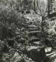
| Description: | A switchback path leading to Cap Carbon and the lighthouse perched near the summit of the peninsula. The lighthouse is built on top of a giant rock that pr... |

| Date: | 1928 |
|---|---|
| Description: | This map shows the Forest Hill Cemetery and is oriented with the north to the lower left. The map shows buildings and section numbers but does not include ... |
If you didn't find the material you searched for, our Library Reference Staff can help.
Call our reference desk at 608-264-6535 or email us at: