 Filter: Categories of Wisconsin Historical Images
Filter: Subject of Trails
Filter: Year of 1900-1999
Filter: Subject of rivers
Filter: Categories of Wisconsin Historical Images
Filter: Subject of Trails
Filter: Year of 1900-1999
Filter: Subject of rivers

| Date: | 1936 |
|---|---|
| Description: | This map is red and black ink on tracing cloth and is oriented with north to the upper left. This hand-drawn map shows a central portion of the military ro... |

| Date: | 1907 |
|---|---|
| Description: | The Yahara River Parkway, with the old Lapham School at 1436 East Dayton Street at North Thornton visible on the righthand side. |

| Date: | 1906 |
|---|---|
| Description: | View from shoreline looking over a pathway towards the Steensland Bridge and Yahara River Parkway at East Washington Avenue. |

| Date: | 1925 |
|---|---|
| Description: | The Pierre Pauquette monument located at the easterm terminus of the Wauona Trail. Erected by the Wau-bun Chapter of the Daughters of the American Revoluti... |
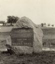
| Date: | 1925 |
|---|---|
| Description: | A view of the Pierre Pauquette monument located at the eastern terminus of the Wauona Trail. Erected by the Wau-bun Chapter of the Daughters of the America... |

| Date: | 1918 |
|---|---|
| Description: | View from shoreline of people rowing on the Yahara River on Madison's East Side. The Malt House, 1603 Sherman Avenue, is in the background. |
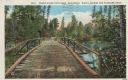
| Date: | 1913 |
|---|---|
| Description: | Colorized postcard of a wooden bridge over the Brule River flowing through the forest. A person is on the far side of the bridge. Caption reads: "Brule Riv... |
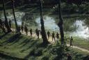
| Date: | 1962 |
|---|---|
| Description: | Elevated view of a group of Vietnamese soldiers wearing berets hiking through a forest in Vietnam. The footpath they are on is bordered on one side by tree... |

| Date: | 1930 |
|---|---|
| Description: | This map shows Indian trails through Wisconsin counties. The trail are in red ink. Lake Michigan, Green Bay, Lake Superior, and the Wisconsin River are lab... |

| Date: | 1919 |
|---|---|
| Description: | This map depicts the route of the 1842 overland trip by wagon made by the Reverend Alfred Brunson and some copper miners from Prairie du Chien to the mouth... |

| Date: | 1920 |
|---|---|
| Description: | Shows 10 land and water trails along rivers and other bodies of water in northern Wisconsin and the Upper Peninsula of Michigan; each trail numbered and de... |

| Date: | 1994 |
|---|---|
| Description: | This brochure consists of a series of 16 maps of the Military Ridge State Park Trail and the Sugar River State Trail. In all, 62 miles of bike trails and 1... |

| Date: | 1904 |
|---|---|
| Description: | A map that shows the location of the lakes and resorts in northeastern Wisconsin that were reachable by the Chicago and North Western Railway. Shown in the... |

| Date: | 1969 |
|---|---|
| Description: | A map of the Elroy-Sparta State Trail and the surrounding area, showing the townships, the towns of Cashton, Sparta, in the west, and Union Center and Elro... |

| Date: | 1952 |
|---|---|
| Description: | This 1952 map shows the trails, roads, and railroads through the counties of Ashland, Bayfield, Sawyer, Price, Iron, and Vilas. Also shown are lakes, river... |

| Date: | 1952 |
|---|---|
| Description: | This map of the northern parts of the Chequamegon Bay area in Bayfield and Ashland counties, Wisconsin, shows trails, roads, railroads, stations, the towns... |

| Date: | 1941 |
|---|---|
| Description: | This 1941 map covers Washburn County, Wisconsin, as well as western Sawyer, eastern Burnett, and northeastern Polk counties. It shows the locations of tour... |

| Date: | 1974 |
|---|---|
| Description: | This 1974 map is a reproduction of the original survey maps of the Four Lakes region of Dane County, Wisconsin. It shows sections, lakes, rivers, wetlands,... |

| Date: | 1968 |
|---|---|
| Description: | This map is ink and color on printed grid. Shows geology, portage trails, timber type, some landownership, hydrology, and marshes in part of Florence Count... |

| Date: | 1960 |
|---|---|
| Description: | This manuscript map of Taylor County, Wisconsin, shows the township and range grid, lakes and streams, "Chippewa trails, Indian trails" Indian villages and... |
If you didn't find the material you searched for, our Library Reference Staff can help.
Call our reference desk at 608-264-6535 or email us at: