 Filter: Categories of Wisconsin Historical Images
Filter: Subject of Trails
Filter: Year of 1900-1999
Filter: Year of 1960-1969
Filter: Categories of Wisconsin Historical Images
Filter: Subject of Trails
Filter: Year of 1900-1999
Filter: Year of 1960-1969
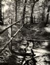
| Date: | 1963 |
|---|---|
| Description: | A trail leading into Parfrey's Glen in Devil's Lake State Park. Parfrey's Glen was Wisconsin's first State Natural Area in 1952. |

| Date: | 1960 |
|---|---|
| Description: | University of Wisconsin-Madison fire lane surrounded by trees and brush. |

| Date: | 05 1961 |
|---|---|
| Description: | Colonel Bounchon's Lao Infantry men on mission to lay explosives behind lines. Three men are hiking up a hill. Rolling green mountains are visible in the b... |
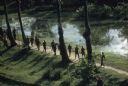
| Date: | 1962 |
|---|---|
| Description: | Elevated view of a group of Vietnamese soldiers wearing berets hiking through a forest in Vietnam. The footpath they are on is bordered on one side by tree... |
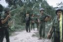
| Date: | 1962 |
|---|---|
| Description: | Small group of Vietnamese soldiers stand with a recently captured prisoner suspected of being Viet Cong on a path in the woods in Vietnam. One soldier is u... |

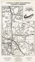
| Date: | 1968 |
|---|---|
| Description: | The map shows fire towers, public camp grounds, roads, snow mobile & riding trails, trout lakes, foot trails, railroads, and National Forest boundaries. |

| Date: | 1969 |
|---|---|
| Description: | A map of the Elroy-Sparta State Trail and the surrounding area, showing the townships, the towns of Cashton, Sparta, in the west, and Union Center and Elro... |

| Date: | 1964 |
|---|---|
| Description: | This 1964 maps shows roads, boat landings and marinas, campgrounds, canoe trails and portages, and lakes and streams in parts of Vilas, Oneida, and Iron co... |

| Date: | 1968 |
|---|---|
| Description: | This map is ink and color on printed grid. Shows geology, portage trails, timber type, some landownership, hydrology, and marshes in part of Florence Count... |

| Date: | 1960 |
|---|---|
| Description: | This manuscript map of Taylor County, Wisconsin, shows the township and range grid, lakes and streams, "Chippewa trails, Indian trails" Indian villages and... |
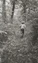
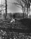
| Date: | 1963 |
|---|---|
| Description: | Young boy, photographed from behind, running along a wooded path. |
| Date: | 1965 |
|---|---|
| Description: | This map covers the vicinity of Arbor Vitae, Woodruff, and Minocqua: east to Mishonagon Creek, west to Gilmore Lake, north to Lower Gresham Lake, and south... |

| Date: | 1966 |
|---|---|
| Description: | This map shows trails, roads, creeks, alleged location of George Gardner's trading post, Boulder and Mud Lakes, and a portion of the Wolf River. The map al... |

| Date: | 1967 |
|---|---|
| Description: | A family of three are portaging their canoe through the brush and trees on the Brule Portage Trail. |
| Date: | 1967 |
|---|---|
| Description: | A group of men and women walking along a gravel path. |

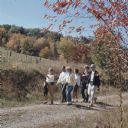
| Date: | 1967 |
|---|---|
| Description: | Two young women and a man are riding horses single file on a narrow dirt path in the Kettle Moraine State Forest. |
| Date: | 1960 |
|---|---|
| Description: | A man is running his dog on a trail in an old lead mining area. The trees are bare and fallen leaves are covering the ground. |
If you didn't find the material you searched for, our Library Reference Staff can help.
Call our reference desk at 608-264-6535 or email us at: