 Filter: Categories of Wisconsin Historical Images
Filter: Subject of Trails
Filter: Year of 1900-1999
Filter: Year of 1980-1989
Filter: Categories of Wisconsin Historical Images
Filter: Subject of Trails
Filter: Year of 1900-1999
Filter: Year of 1980-1989
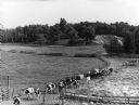
| Date: | 08 1983 |
|---|---|
| Description: | "Late in the day, the cows return for milking on the Batzler farm." |

| Date: | 04 1984 |
|---|---|
| Description: | The 'Yellowstone Trail' at one time passed through the village. Les Beck displays a sign next to a present day road sign." |

| Date: | 1986 |
|---|---|
| Description: | This late 1980s map of Price County, Wisconsin, shows facilities and lands open for public recreation, hunter walking trails and ski trails, campgrounds, b... |

| Date: | 03 20 1986 |
|---|---|
| Description: | View of Quarry Drive, a sunken path lined with trees, near Mendota Heights. Branches and stones obstruct the pathway. |

| Date: | 1980 |
|---|---|
| Description: | This map shows the locations of 42 businesses, roads, points of interest, recreation sites, camping, the North Country Trail and parking, and boundaries of... |

| Date: | 1983 |
|---|---|
| Description: | This map covers Vilas county as well as parts of Iron, Oneida, and Forest counties. Club trails are shown in dotted red lines and state trails are shown in... |
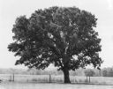
| Date: | 1980 |
|---|---|
| Description: | A mature, dense bur oak standing within a small fenced plot surrounded by a field. There is a wooded area in the background. This tree marked the half-way ... |
If you didn't find the material you searched for, our Library Reference Staff can help.
Call our reference desk at 608-264-6535 or email us at: