 Filter: Categories of Wisconsin Historical Images
Filter: Subject of Water
Filter: County of Taylor
Filter: Categories of Wisconsin Historical Images
Filter: Subject of Water
Filter: County of Taylor
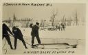
| Date: | 01 25 1911 |
|---|---|
| Description: | Photomontage of a winter scene with men fishing on a frozen lake. Two men pull on the line attached to the fish's mouth, while one holds an axe above its h... |
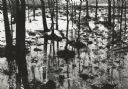
| Date: | 05 10 1960 |
|---|---|
| Description: | Grove of trees in a flooded area from a late snow melt. |
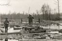
| Date: | 1910 |
|---|---|
| Description: | Logging crew standing on planks and logs possibly in a sorting works on the Yellow River. One man holds a ledger and the others hold long cant hooks. |

| Date: | 1895 |
|---|---|
| Description: | A promotional card displaying a populated village street near a lake in Northern Wisconsin. The caption bellow the photography reads: "RIB LAKE, TAYLOR C... |

| Date: | 1887 |
|---|---|
| Description: | This 1887 map of Taylor County, Wisconsin, shows the township and range system, sections, railroads, vacant Wisconsin Central Railroad land, land sold by t... |

| Date: | 1887 |
|---|---|
| Description: | This 1896 map shows the township and range system, sections, cities and villages, railroads, roads, vacant land and land sold by the Wisconsin Central Rail... |

| Date: | 1909 |
|---|---|
| Description: | This 1909 map of Taylor County, Wisconsin, shows the township and range grid, towns, sections, cities and villages, settlers houses, schools, churches, saw... |

| Date: | |
|---|---|
| Description: | This map of Taylor County, Wisconsin, shows soil types, the township and range grid, sections, settlers houses, schools, churches, saw mills, tanneries, ro... |

| Date: | 1940 |
|---|---|
| Description: | This map of Taylor County, Wisconsin, shows the township and range grid, towns, sections, cities and villages, railroads, roads, creameries and cheese fact... |

| Date: | 1960 |
|---|---|
| Description: | This manuscript map of Taylor County, Wisconsin, shows the township and range grid, lakes and streams, "Chippewa trails, Indian trails" Indian villages and... |

| Date: | 1930 |
|---|---|
| Description: | This map shows communities, state roads, county roads, railroads, lakes and rivers in the county. Areas marked in red are lands tax deeded to the county. |

| Date: | 03 06 1913 |
|---|---|
| Description: | Text on front reads: "North Harper Lake", "Photo by Brown", and "A Souvenir from Rib Lake, Wis." A view of the lake from a rise, surrounded by trees and sh... |

| Date: | 1940 |
|---|---|
| Description: | Text on front reads: "Harper Lake Resort, Westboro, Wis." Swimming dock with a ladder leading up to a diving platrom on Harper Lake. A rowboat is moored to... |
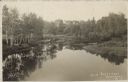
| Date: | 10 01 1913 |
|---|---|
| Description: | Text on front reads: "Scene Near Westboro, Wis." Water scene with a boat at the shore on the left. Trees, shrubs and foliage fill the landscape along the s... |
If you didn't find the material you searched for, our Library Reference Staff can help.
Call our reference desk at 608-264-6535 or email us at:
