Filter: Categories of Wisconsin Historical Images
Filter: Subject of Water
Filter: County of Winnebago
Filter: Categories of Wisconsin Historical Images
Filter: Subject of Water
Filter: County of Winnebago
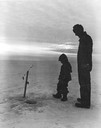
| Date: | 1960 |
|---|---|
| Description: | Man and boy in silhouette ice fishing on Lake Winnebago. |

| Date: | 1870 |
|---|---|
| Description: | This bird's-eye-view map shows roads, a river with boats, and homes. The bottom margin of the map includes an index. |
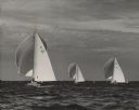
| Date: | |
|---|---|
| Description: | Three sailboats on Lake Winnebago, U50 (Eskimo), U7 and J7. Crew members are on the boats. The water is choppy and the sky is cloudy. In the background are... |

| Date: | 1855 |
|---|---|
| Description: | Quarter plate daguerreotype of the Oshkosh harbor, showing the bridge over the Fox River and several moored sailing vessels. |

| Date: | 1850 |
|---|---|
| Description: | Bird's-eye view of business district of Oshkosh, "drawn after nature" by the artist. |

| Date: | 1867 |
|---|---|
| Description: | Bird's-eye view of Oshkosh, "drawn from nature." |
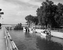
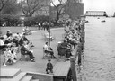
| Date: | |
|---|---|
| Description: | People on recreational boats waiting for the Menasha Locks to open into the Fox River. |
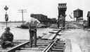
| Date: | 1915 |
|---|---|
| Description: | Four men inspecting the washout of Minneapolis, St. Paul and Sault Ste. Marie tracks caused by a flood at Medina Junction. The view is looking west from th... |
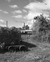
| Date: | 09 14 1963 |
|---|---|
| Description: | The Marathon Paper Corporation plant along the historic Fox River canal. |
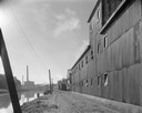
| Date: | 09 29 1963 |
|---|---|
| Description: | The Menasha Woodenware plant and water tower on Doty Island from across the Fox River canal, with a small railroad dolly in the foreground. |
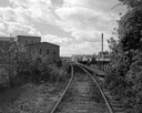
| Date: | 09 29 1963 |
|---|---|
| Description: | View down railroad tracks towards the railroad bridge, with industrial plants on Doty Island. |

| Date: | 1833 |
|---|---|
| Description: | Map of part of the military road from Fort Crawford to Fort Howard. "Recorded on pages 668.669 Book B." Surveyed by Lieut. Center. Scale: 2 miles = 1 inch. |
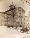
| Date: | 1893 |
|---|---|
| Description: | Institutional fire fighting department at the Northern Hospital for the Insane, executing drills on the exterior of the building. Fire fighting equipment i... |
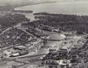
| Date: | 1955 |
|---|---|
| Description: | Aerial view of "the island" with the Marathon Corporation paper mills. The Fox River flowing out of Lake Winnebago separates the two cities, Neenah and Men... |

| Date: | 1870 |
|---|---|
| Description: | Elevated view of City Square, where the Bank of Menasha is seen on the corner and Little Lake Butte des Mortes is in the distance. |
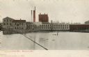
| Date: | 1905 |
|---|---|
| Description: | The Island Paper Mill and dam in Menasha. Caption reads: "Paper Mill, Menasha, Wis." |
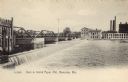
| Date: | 1905 |
|---|---|
| Description: | The Island Paper Mill and dam in Menasha. Caption reads: "Dam & Island Paper Mill, Menasha, Wis." |
If you didn't find the material you searched for, our Library Reference Staff can help.
Call our reference desk at 608-264-6535 or email us at: