 Filter: Categories of Wisconsin Historical Images
Filter: Subject of Wisconsin River (Wis.)
Filter: Year of 1800-1899
Filter: Categories of Wisconsin Historical Images
Filter: Subject of Wisconsin River (Wis.)
Filter: Year of 1800-1899

| Date: | 1896 |
|---|---|
| Description: | Section 5 of 12, this bicycle road map features Wisconsin bicycle routes in the counties of La Crosse, Monroe, Vernon, Crawford, Richland, Sauk, Juneau, an... |

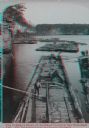
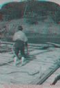
| Date: | 1890 |
|---|---|
| Description: | Elevated view of men working on lumber rafts on the Wisconsin River. |

| Date: | 1878 |
|---|---|
| Description: | Illustrated map of Crawford County. On the bottom right is an inset of a group of people near a train on a railroad track. |
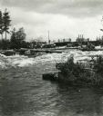
| Date: | 1895 |
|---|---|
| Description: | Crew of river drivers moving logs off of rocks below a dam probably on the Wisconsin River. |
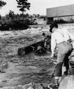
| Date: | 1890 |
|---|---|
| Description: | Log driving crew maneuvering logs through rapids below a dam, probably on the Wisconsin River. |
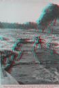
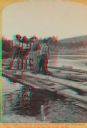
| Date: | 1886 |
|---|---|
| Description: | Stereograph view of several groups of men on rafts loaded with felled trees. |
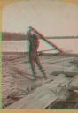
| Date: | 1886 |
|---|---|
| Description: | Stereograph of a man on a lumber raft steering the raft through the rapids in the Wisconsin Dells. |

| Date: | 1886 |
|---|---|
| Description: | Stereograph of a man lying on his stomach on a raft drinking water from the river. A second man is crouching on the edge of the raft, while a third man is ... |
| Date: | 1886 |
|---|---|
| Description: | Stereograph of a raftsman holding a rope as a second man is running towards the edge of the raft. |

| Date: | 1886 |
|---|---|
| Description: | Stereograph of several men working at dusk, knee deep in water attending to the raft. |
| Date: | 1886 |
|---|---|
| Description: | Stereograph of photographer Henry Hamilton Bennett pulling an oar on a Wisconsin raft. |
| Date: | 1886 |
|---|---|
| Description: | Stereograph of five men standing on a log while another man chops at the log with an axe. |

| Date: | 1844 |
|---|---|
| Description: | A hand-colored map and chart showing a geological cross-section from Rockingham, in present-day Scott County, Iowa, through Blue Mounds to the Wisconsin Ri... |

| Date: | 1835 |
|---|---|
| Description: | Ink on tracing paper map of Green Bay, Wisconsin and nearby areas, Lake Winnebago, Fox and Wolf Rivers, and the junctions of the Mississippi and Wisconsin ... |

| Date: | 1899 |
|---|---|
| Description: | This color map, originally published in the Smithsonian Institution Bureau of American Ethnology's 18th annual report, shows the Indian land cessions in Wi... |

| Date: | 1896 |
|---|---|
| Description: | A map showing the Wisconsin Central Railroad lines in Wisconsin, northern Illinois, eastern Minnesota, and Michigan’s Upper Peninsula. The area of the map ... |

| Date: | 1852 |
|---|---|
| Description: | Hand-colored maps and a series of geological cross sections of the Mississippi River between the Falls of St. Anthony and the mouth of the Wisconsin River ... |

| Date: | 1846 |
|---|---|
| Description: | A map of Wisconsin and a portion of Minnesota that show the township surveys in progress in portions of the Saint Croix River region and in central Wiscons... |

| Date: | 1854 |
|---|---|
| Description: | This map is ink and watercolor on tracing cloth and shows lot and block numbers, streets, a park, and depots. Some lots are colored red or blue and some in... |

| Date: | 1847 |
|---|---|
| Description: | A geological, hand-colored map of Wisconsin north and west of the Wisconsin River, as well as portions of eastern Minnesota and Iowa from the Mississippi t... |
If you didn't find the material you searched for, our Library Reference Staff can help.
Call our reference desk at 608-264-6535 or email us at: