 Filter: Categories of Wisconsin Historical Images
Filter: Subject of coasts
Filter: Categories of Wisconsin Historical Images
Filter: Subject of coasts

| Date: | |
|---|---|
| Description: | Passenger side view of Scout parked on beach. The Scout has a windshield and roll bars in place, but no doors. The ocean is in the background. |

| Date: | |
|---|---|
| Description: | Three-quarter view from front of driver's side of Scout parked on beach. The Scout has a windshield and roll bars in place, but no doors. The ocean is in t... |

| Date: | |
|---|---|
| Description: | Driver's side view of Scout parked on beach. The Scout has a windshield and roll bars in place, but no doors. A white helmet is sitting on the driver's sea... |

| Date: | 1968 |
|---|---|
| Description: | Three-quarter view from front of passenger side of red International Scout with white Traveltop. Two people are in the front seat. The sides of the Travelt... |

| Date: | 1671 |
|---|---|
| Description: | Map of Virginia depicting the discoveries detailed by John Smith in his exploration of the region. It shows Jamestown, Native American tribes and villages,... |

| Date: | 1719 |
|---|---|
| Description: | Map of Maryland and surrounding states. It shows the boundaries, counties, cities, towns, rivers, and bays. Mountains, forests, and swamps appear pictoria... |

| Date: | 1795 |
|---|---|
| Description: | Map of Connecticut showing counties, townships, cities, roads, islands, swamps, hills, mountains, lakes, rivers, reefs, and numerous other geographical and... |

| Date: | 1795 |
|---|---|
| Description: | Map of Rhode Island showing counties, townships, cities, roads, mountains, swamps, islands, reefs, lakes and rivers. Several of the bigger cities include s... |

| Date: | 1780 |
|---|---|
| Description: | Map of Connecticut, Rhode Island, and Long Island. it shows the borders, cities, roads, islands, mountains, lakes and rivers. Navigational hazards along th... |

| Date: | 1795 |
|---|---|
| Description: | Map of Maine, showing a few cities, harbors, hills, mountains, lakes, and rivers. A road runs from Pownalboro south to Portsmouth harbor, and the boundary ... |

| Date: | 1794 |
|---|---|
| Description: | Extremely detailed map of the south-eastern states, south from Virginia and east of the Mississippi River. It shows roads and paths, cities, towns, forts, ... |
| Date: | 1780 |
|---|---|
| Description: | Map of Florida and the south eastern States. The map shows cities, towns, forts, Native American land, mountains, rivers, and lakes. A small inset map of t... |

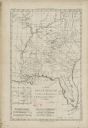
| Date: | 1752 |
|---|---|
| Description: | Map of the the coast line of Louisiana, focusing on the Mississippi, the Arkansas, the Red, the Osage, and the Missouri River. An inset map along the righ... |

| Date: | 1700 |
|---|---|
| Description: | Map of the British colonies in North America at the beginning of the eighteenth century. It includes five inset maps of Nova Scotia, Jamaica, Bermuda, Barb... |

| Date: | 1776 |
|---|---|
| Description: | Map showing New England, Nova Scotia, and Newfoundland, based on the seminal work of D' Anville, as well as the works of Belllin and de Vaugondy. It shows ... |

| Date: | 1783 |
|---|---|
| Description: | Map of eastern Canada and part of America, with an inset map of the Great Lakes region in the lower left corner. It shows boundaries, cities, settlements, ... |
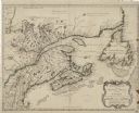
| Date: | 1755 |
|---|---|
| Description: | Bellin's landmark map of eastern Canada and part of northeast America extending from Newfoundland to the borders of Lake Ontario and south to Cape Cod. The... |

| Date: | 1759 |
|---|---|
| Description: | Map of north eastern Canada and parts of New England, showing settlements, cities, portages, Native American land, mountains, lakes, and rivers. The unusua... |

| Date: | 1755 |
|---|---|
| Description: | Map of the northeastern portion of America and Canada, east of the Hudson River and south from Labrador. It names regions, colonies, cities, numerous forts... |

| Date: | 1796 |
|---|---|
| Description: | An interesting depiction of North America from the North Pole to the beginning of South America. The continent appears elongated. The map features numerous... |
If you didn't find the material you searched for, our Library Reference Staff can help.
Call our reference desk at 608-264-6535 or email us at: