 Filter: Categories of Wisconsin Historical Images
Filter: Subject of education
Filter: Community of Eau Claire
Filter: Year of 1800-1899
Filter: Categories of Wisconsin Historical Images
Filter: Subject of education
Filter: Community of Eau Claire
Filter: Year of 1800-1899

| Date: | 1872 |
|---|---|
| Description: | Birds-eye drawing of Eau Claire depicts street names and street locations, houses, trees, bridges, piers, canals, railroads, and the Chippewa and Eau Clair... |

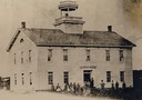
| Date: | 1870 |
|---|---|
| Description: | Third Ward, East Side, or "Bartlett School." This is probably the earliest picture in existence and is copied form the margin of "an old map." This first... |
| Date: | 1885 |
|---|---|
| Description: | The Third Ward, East Side, or Barlett School, after additions had been put on in the rear. The Bartlett after whom the school building was named was Willia... |

| Date: | 1870 |
|---|---|
| Description: | Elevated view of the town, looking northwest. The Chippewa River is in the foreground, with a lot of buildings, an intersection, and distant hills. One bui... |
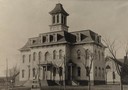
| Date: | 1885 |
|---|---|
| Description: | Front entry way to the "Washington" school, on the northwest corner of Fifth Avenue and Broadway. |
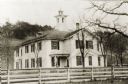
| Date: | 1860 |
|---|---|
| Description: | Front entry to the Wesleyan Seminary. It was built in the early 1860's on the site of the present High School building. |

| Date: | 1889 |
|---|---|
| Description: | Shows city limits, railroads, mills, schools, cemeteries, dams, parks, lumber yards, log canals, log reservoir, Chippewa River, Eau Claire River, and Half ... |
If you didn't find the material you searched for, our Library Reference Staff can help.
Call our reference desk at 608-264-6535 or email us at: