 Filter: Categories of Wisconsin Historical Images
Filter: Subject of folklore
Filter: Categories of Wisconsin Historical Images
Filter: Subject of folklore
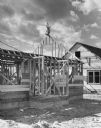
| Date: | 04 22 1953 |
|---|---|
| Description: | View of a building under construction. A small tree is mounted on the gable. Caption reads: "Small tree placed atop frame of newly erected barn – an old cu... |
| Date: | |
|---|---|
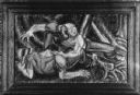
| Description: | Framed mural depicting two men struggling against each other. One is holding an axe. Caption reads: "Fight incident from Paul Bunyan legend. Mural painting... |

| Date: | |
|---|---|
| Description: | A sculpture of the mythical hodag is posed in a clearing. Caption reads: "RHINELANDER WISCONSIN 'HOME OF THE HODAG' On the first night of the arrival ... |

| Date: | 07 25 2015 |
|---|---|
| Description: | Carved wooden figure of a Nisse playing a fiddle. The figure has a long white beard and is wearing a red cap. Norwegian words carved into the base of the f... |

| Date: | 1967 |
|---|---|
| Description: | A family looking at a sculpture of a Hodag in a glass case at the Rhinelander Logging Museum. |

| Date: | 1720 |
|---|---|
| Description: | Map of North America from from the Rio Grande to the Atlantic Ocean, showing boundaries, the colonies, cities, settlements, mines, forts, Native American l... |

| Date: | 1759 |
|---|---|
| Description: | Map of north eastern Canada and parts of New England, showing settlements, cities, portages, Native American land, mountains, lakes, and rivers. The unusua... |

| Date: | 1770 |
|---|---|
| Description: | Map of North America showing the boundaries between French, Spanish, and English claims after the French and Indian War. Kitchin includes numerous place na... |

| Date: | 1790 |
|---|---|
| Description: | Map of North America showing cities, states, Native American land, regions, lakes, and rivers. A few notes appear throughout the map, particularly west of ... |

| Date: | 1690 |
|---|---|
| Description: | A mysterious mixture of mythology, ancient geography, and late 17th century knowledge of the American coastline. This map shows North and South America, bu... |

| Date: | 1627 |
|---|---|
| Description: | Map of North and South America showing settlements, rivers, lakes, mountains, islands and regions of the western hemisphere. It includes an inset map of Gr... |

| Date: | 1778 |
|---|---|
| Description: | Map of European claims in North America, with France shown as having claim to the most land, and the British colonies confined to east of the Appalacian Mo... |

| Date: | 1777 |
|---|---|
| Description: | This important map highlights the frantic desire and search for the north west passage. It shows a few settlements and mountains in Russia, north west Amer... |

| Date: | 1772 |
|---|---|
| Description: | Map of the north west portion of America and Canada, as well as a small section of eastern Russia. Lakes, rivers, Native American land and the occasional ... |

| Date: | 1740 |
|---|---|
| Description: | Map including the regions and cities of the northern half of North America. Native American land, rivers, lakes, mountains are labeled. Mountains, marshes,... |

| Date: | 1722 |
|---|---|
| Description: | Map of North America including mountains, rivers, lakes, regions, and a few of the most important cities. A highly unusual map with interesting inaccuracie... |
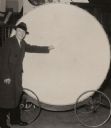
| Date: | |
|---|---|
| Description: | Man in a long coat and hat standing with the large Paul Bunyan drum, which is mounted on wheels. |
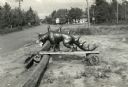
| Date: | |
|---|---|
| Description: | Hodag standing on a board balanced on logs near a road. There is a gasoline filling station in the background. |
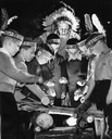
| Date: | 01 27 1963 |
|---|---|
| Description: | Young Caucasian boys dressed like Native Americans as part of their YMCA "Indian Guides" program. They are being directed by the "All Nations Chief" Henry ... |
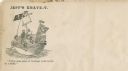
| Date: | 1860 |
|---|---|
| Description: | Jefferson Davis and six sailors sail in a tea cup. A pirate flag flies overhead. One sailor is in the "crow's nest." Another is using a paddle. Three sailo... |
If you didn't find the material you searched for, our Library Reference Staff can help.
Call our reference desk at 608-264-6535 or email us at: