Filter: Categories of Wisconsin Historical Images
Filter: Subject of indians of north america
Filter: County of Ashland
Filter: Creator Name of Unknown
Filter: Categories of Wisconsin Historical Images
Filter: Subject of indians of north america
Filter: County of Ashland
Filter: Creator Name of Unknown
| Date: | 1935 |
|---|---|
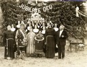
| Description: | Father Gumbly and Sisters, with three Native Americans in ceremonial dress, standing outdoors in front of altar. |
| Date: | |
|---|---|
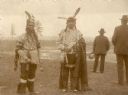
| Description: | Chief Cloud, in center, of the Chippewa Indians (Ojibwa) standing outdoors with other men. |
| Date: | 1891 |
|---|---|
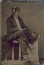
| Description: | Tintype (ferrotype) portrait of Shadomo, or Dirty Pelican, a Chippewa (Ojibwa) from the Odanah Reservation near Ashland. |
| Date: | |
|---|---|
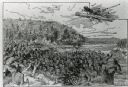
| Description: | An illustration titled "The Battle of the Brule" based on an 1840's battle between the Ojibwe and Dakota Sioux over territory in the Ashland, Wisconsin are... |
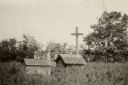
| Date: | 1959 |
|---|---|
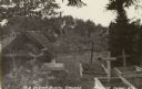
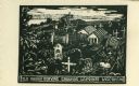
| Description: | Caption reads: "Old Indian Burying Grounds LaPointe Wisconsin." |

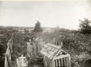
| Date: | 1905 |
|---|---|
| Description: | Indian cemetery. A large body of water is in the background. Caption reads: "Indian Burying Grounds, Bayfield, Wis." |
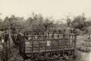
| Date: | 1918 |
|---|---|
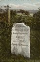
| Description: | The O-Sho-Ga monument near the Indian burial grounds. Caption reads: "Apostle Islands, Wis. Madeline Island, La Pointe, O-Sho-Ga Monument near the old Indi... |
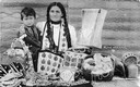
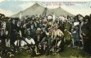
| Date: | 1912 |
|---|---|
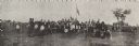
| Description: | Panoramic image of Chippewa (Ojibwa) Indians at a fair in northern Wisconsin. Caption under the image reads, "Souvenier [sic] of Odanah, Fair 1913."... |
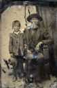
| Date: | 1854 |
|---|---|
| Description: | Tintype of Michael De Perry and unidentified child. |
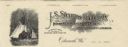
| Date: | |
|---|---|
| Description: | Letterhead of the J.S. Stearns Lumber Company of Odanah, Wisconsin, manufacturers of "Indian Reservation Soft Pine and Norway Lumber" and general merchandi... |
| Date: | 1896 |
|---|---|
| Description: | Colored postcard view of "Buffalo Bill" Cody center right in white coat and hat surrounded by Native Americans in traditional garb, military personnel and ... |

| Date: | 1890 |
|---|---|
| Description: | This map shows the Wisconsin Central Railroad land grant lands owned and for sale by the Soo Line in Ashland County, Wisconsin, as well as in portions of B... |

| Date: | 1890 |
|---|---|
| Description: | This 1890s map shows the Wisconsin Central Railroad land grant lands owned and for sale by the Soo Line in Ashland County, Wisconsin, as well as in the eas... |
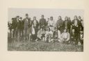
| Date: | 1852 |
|---|---|
| Description: | Group portrait of members of the La Pointe Band (now known as the Bad River La Pointe Band) of the Ojibwe Nation awaiting annuity payment at La Pointe. Non... |

| Date: | 1915 |
|---|---|
| Description: | This map shows school houses, churches, farms, and railroads. Chequamecon Bay and Bad River Indian Reservation are labeld. The map reads: "All lands shown ... |
If you didn't find the material you searched for, our Library Reference Staff can help.
Call our reference desk at 608-264-6535 or email us at: