Filter: Categories of Wisconsin Historical Images
Filter: Subject of oneida indians
Filter: Categories of Wisconsin Historical Images
Filter: Subject of oneida indians
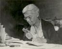
| Date: | 1949 |
|---|---|
| Description: | Portrait of Dr. Lillie Rosa Minoka Hill, a physician of Mohawk ancestry. She is sitting at a table examining a book through a magnifying glass. Dr. Minoka ... |
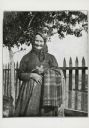
| Date: | 1909 |
|---|---|
| Description: | Portrait of a woman, who is wearing a dress and a kerchief knotted around her hair. She is holding some cloth over her arm, and an unidentified object in h... |
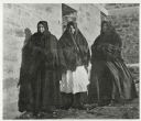
| Date: | 1899 |
|---|---|
| Description: | Group portrait of three women standing outside against a brick building. All three women are wearing dresses, with shawls covering their shoulders and head... |
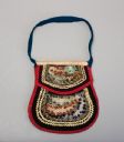
| Date: | |
|---|---|
| Description: | A small beaded bag created by a member of the Oneida tribe. |

| Date: | 1911 |
|---|---|
| Description: | Three-quarter length studio portrait in front of a painted backdrop of Laura M. Cornelius. She is wearing a long coat and a hat with flowers. |

| Date: | 1930 |
|---|---|
| Description: | A map of the site of a Native American village with a complex of linear raised garden beds and cache pits near Leeman. Also shown are a farmstead, road, an... |

| Date: | 1790 |
|---|---|
| Description: | This map of the north eastern states shows roads, rivers, lakes, waterfalls, mountains, cities, forts, mills, the Oneida Reservation, and "New York Donatio... |
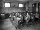
| Date: | 1910 |
|---|---|
| Description: | Oneida children seated at their desks in a classroom. |

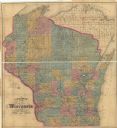
| Date: | 1867 |
|---|---|
| Description: | A hand-colored map of Wisconsin showing the state’s township grid, lakes, rivers, railroads, as well as the locations of towns, counties and the reservatio... |

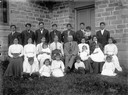
| Date: | 10 1914 |
|---|---|
| Description: | Fourth Annual Conference of American Indians taken in front of Lathrop Hall, University of Wisconsin-Madison campus. Included are: Mr. (William) Kershaw (M... |

| Date: | 1875 |
|---|---|
| Description: | This hand-colored map of Wisconsin and the western portion of Michigan's Upper Peninsula depicts the township survey grid and identifies counties, named to... |

| Date: | 1880 |
|---|---|
| Description: | A hand-colored, sectional map of Wisconsin showing the township grid, railroads, counties, towns, cities, villages, and the Menomonee, Oneida, Flambeau, an... |

| Date: | 1882 |
|---|---|
| Description: | A hand-colored, sectional map of Wisconsin showing the township grid, completed and proposed railroads, counties, towns, cities, villages. The map also inc... |
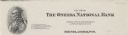
| Date: | |
|---|---|
| Description: | Numbered memohead of the Oneida National Bank of Rhinelander, Wisconsin, with a profile view of a Native American man wearing beads, feathers, a ribbon in ... |

| Date: | 1860 |
|---|---|
| Description: | A survey map of Wisconsin, southeastern Minnesota, and northern Iowa, showing the status of surveys, rivers, and lakes. The map also shows the locations of... |

| Date: | 1856 |
|---|---|
| Description: | This map of shows the township survey grid and identifies counties, named towns, cities and villages, rivers, lakes, railroads, roads, and the Menomonee an... |

| Date: | 1873 |
|---|---|
| Description: | This hand-colored map of Wisconsin depicts the township survey grid and identifies counties, named towns, cities and villages, rivers, lakes, railroads, an... |
| Date: | 1910 |
|---|---|
| Description: | A Native American family posing outside of the Hobart Church. |
| Date: | 1872 |
|---|---|
| Description: | This map of Wisconsin depicts the township survey grid and identifies counties, named towns, cities and villages, rivers, lakes, railroads, and the Chippew... |
If you didn't find the material you searched for, our Library Reference Staff can help.
Call our reference desk at 608-264-6535 or email us at: