 Filter: Categories of Wisconsin Historical Images
Filter: Subject of political science
Filter: Type of Map or Atlas
Filter: Year of 1800-1899
Filter: Categories of Wisconsin Historical Images
Filter: Subject of political science
Filter: Type of Map or Atlas
Filter: Year of 1800-1899

| Date: | 1889 |
|---|---|
| Description: | Illustration of the exterior of the Fuller Opera House, which is a detail from a bird's-eye view map of Madison. |

| Date: | 1898 |
|---|---|
| Description: | Bird's-eye map of Milwaukee with prominent streets and buildings identified. Taken from City Hall Tower. |

| Date: | 1878 |
|---|---|
| Description: | Bird's-eye map of Chilton with insets of points of interest, including P.H. Becker's Brewery, Chilton House, and Gutheil's Block. |

| Date: | 1862 |
|---|---|
| Description: | Lithography of C. Van Benthuysen. |

| Date: | 1835 |
|---|---|
| Description: | Map reads: "Map of the United States of America with its Territories and Districts - Including also a part of Upper and Lower Canada and Mexico". The map i... |

| Date: | 1855 |
|---|---|
| Description: | Map reads "Our Country" which is accompanied by a sailor with a flag to the left and workers rejoicing under the Constitution and Laws to the right. Across... |

| Date: | 1861 |
|---|---|
| Description: | A general map of Pennsylvania, Virginia, New Jersey and Delaware. Insets include maps of New Orleans, Baltimore, St. Louis, Charleston, Savannah, Washingto... |

| Date: | 1883 |
|---|---|
| Description: | A hand-colored map of Wisconsin showing the nine congressional districts, it also shows the counties, cities, railroads, rivers, and lakes in the state. |

| Date: | 1845 |
|---|---|
| Description: | Wisconsin was considered part of Michigan Territory until 1836, a year before Michigan entered statehood. Drawn three years before Wisconsin entered stateh... |

| Date: | 1898 |
|---|---|
| Description: | A hand-colored, cloth mounted map of Wisconsin showing the state’s congressional districts. The map also shows the counties, cities, towns, villages, river... |

| Date: | 1889 |
|---|---|
| Description: | Shows city limits, railroads, mills, schools, cemeteries, dams, parks, lumber yards, log canals, log reservoir, Chippewa River, Eau Claire River, and Half ... |

| Date: | 05 01 1899 |
|---|---|
| Description: | Map showing the Schuylkill River with roads, ferries, and points of interest from Valley Forge to Philadelphia, Pennsylvania as it appeared during the Revo... |

| Date: | 1878 |
|---|---|
| Description: | This map shows 13 districts throughout the state. Congressional districts are outlined in red and judicial districts are outlined in blue as show borders a... |

| Date: | 1878 |
|---|---|
| Description: | This map shows ward boundaries in red, as well as counties, communities, rivers, lakes, Lake Michigan, and Lake Superior. The bottom left corner includes a... |
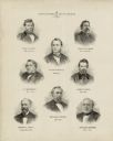
| Date: | 1878 |
|---|---|
| Description: | This print shows eight former Governors of Wisconsin. In date order: "Louis P. Harvey, 1862 til April 20"; "Edward Salomon, April 20 1862-1864"; "James T. ... |

| Date: | 1853 |
|---|---|
| Description: | A map of Wellfleet Harbor on Cape Cod Bay. |
If you didn't find the material you searched for, our Library Reference Staff can help.
Call our reference desk at 608-264-6535 or email us at: