Filter: Categories of Wisconsin Historical Images
Filter: GENRE of Map or Atlas
Filter: Year of 1800-1899
Filter: Categories of Wisconsin Historical Images
Filter: GENRE of Map or Atlas
Filter: Year of 1800-1899

| Date: | 1871 |
|---|---|
| Description: | Birds eye map of Brodhead, WI depicts street names and street locations, houses, and trees. A reference key at the bottom of the map shows the locations of... |

| Date: | 1882 |
|---|---|
| Description: | This map of Cedarburg is a bird's-eye map with an inset of Cedarburg Brewery. Relief is shown pictorially and the map includes an index to buildings. |

| Date: | 1878 |
|---|---|
| Description: | Bird's-eye map of Chilton with insets of points of interest, including P.H. Becker's Brewery, Chilton House, and Gutheil's Block. |

| Date: | 1874 |
|---|---|
| Description: | Bird's-eye map of Chippewa Falls. |
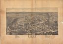
| Date: | 1871 |
|---|---|
| Description: | Darlington, county seat of Lafayette County, was established in the late 1840s, but didn't thrive until the arrival of the railroad in 1856. This view show... |

| Date: | 1881 |
|---|---|
| Description: | Darlington's first settlers arrived by 1826, attracted by the lead mines of the area. Arrival of the railroad in 1856 stimulated growth, and in 1857 the co... |

| Date: | 1896 |
|---|---|
| Description: | Bird's-eye map of Darlington. Area bordered by Washington and North Streets, upper left hand corner, the fairgrounds, upper right corner, River Street, bot... |
| Date: | 1875 |
|---|---|
| Description: | Bird's-eye map of Dodgeville, looking east, with insets of the high school and county courthouse. |

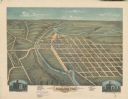
| Date: | 1872 |
|---|---|
| Description: | Birds-eye drawing of Eau Claire depicts street names and street locations, houses, trees, bridges, piers, canals, railroads, and the Chippewa and Eau Clair... |

| Date: | 1891 |
|---|---|
| Description: | Bird's-eye view of Eau Claire. |
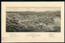
| Date: | 1881 |
|---|---|
| Description: | The county and city of Florence were named for Florence Hulst, the wife of an early settler. This view illustrates the two industries, mining and lumbering... |

| Date: | 1896 |
|---|---|
| Description: | Bird's-eye map of Fond du Lac, looking north west, with two insets of the P.H. Stamm residence, and the Proposed Lakeside Park. thirty-five locations ident... |

| Date: | 1893 |
|---|---|
| Description: | This photocopy of a bird’s-eye-view map shows illustrated houses and various buildings. Streets and the Rock River are labeled. An index to points of inter... |

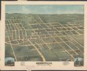
| Date: | 1874 |
|---|---|
| Description: | Bird's-eye map of Grand Rapids. |

| Date: | 1880 |
|---|---|
| Description: | Bird's-eye map over the Mississippi River of Fountain City. Paddle steamers and steamboats are on the river, and bluffs are in the background. |

| Date: | 1893 |
|---|---|
| Description: | Bird's-eye map of Green Bay and Fort Howard, looking south. Ninety-four locations identified below image; extends to Grignon Street at top left corner, Wi... |
If you didn't find the material you searched for, our Library Reference Staff can help.
Call our reference desk at 608-264-6535 or email us at: