 Filter: Categories of Wisconsin Historical Images
Filter: State of Virginia
Filter: Subject of arts
Filter: Subject of human settlements
Filter: Categories of Wisconsin Historical Images
Filter: State of Virginia
Filter: Subject of arts
Filter: Subject of human settlements
| Date: | 1929 |
|---|---|
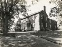
| Description: | A production still of the McCormick home at Walnut Grove for the Fox Hearst film "Romance of the Reaper". The film was produced by International Harvester ... |

| Date: | 1929 |
|---|---|
| Description: | Production still for the Fox Hearst film "Romance of the Reaper". The film was produced by International Harvester at Walnut Grove to celebrate the Reaper ... |

| Date: | |
|---|---|
| Description: | Amateur painting by Eleanor R. Craighill. Representing a woman in an apron and hat polishing(?) a pot in front of the kitchen fireplace in the Governor's P... |

| Date: | |
|---|---|
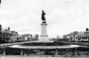
| Description: | A monument and statue honoring the Confederate general Thomas Jonathan "Stonewall" Jackson. There is a cemetery in the background on the left. |

| Date: | 1870 |
|---|---|
| Description: | A stereograph of a statue of Thomas J. "Stonewall" Jackson. |

| Date: | 1870 |
|---|---|
| Description: | A stereograph of a statue of Thomas J. "Stonewall" Jackson. |
| Date: | |
|---|---|
| Description: | Bronze statue of Hugh Mercer (1726-1777), Physician and Brigadier General of the Continental Army during the Revolutionary War. Mercer died of wound he rec... |

| Date: | |
|---|---|
| Description: | View of the Henry Clay Monument with a statue of Clay inside. In front stand two young girls wearing dresses. Each girl is holding a pet rabbit. On the rig... |

| Date: | 1770 |
|---|---|
| Description: | The south west sheet of a four sheet map of Virginia, showing the counties, mountains, rivers, court houses, a few cities, and mills. A few Plantations ar... |

| Date: | 1671 |
|---|---|
| Description: | Map of Virginia depicting the discoveries detailed by John Smith in his exploration of the region. It shows Jamestown, Native American tribes and villages,... |

| Date: | 1755 |
|---|---|
| Description: | Map of Virginia and parts of Maryland, North Carolina, and New Jersey. It shows borders, boundary lines, some Native American land, counties, cities, towns... |

| Date: | 1762 |
|---|---|
| Description: | Map of Virginia and parts of Maryland. It shows borders, boundary lines, Native American tribes and land, towns, forts, roads, mountains, waterfalls, bays,... |

| Date: | 1781 |
|---|---|
| Description: | Map of the southern portion of the Chesapeake Bay and surrounding lands. It shows counties, a few cities and towns, forts, roads, islands, topographical fe... |
If you didn't find the material you searched for, our Library Reference Staff can help.
Call our reference desk at 608-264-6535 or email us at: