 Filter: Categories of Wisconsin Historical Images
Filter: State of Virginia
Filter: Subject of intellectual life
Filter: Subject of water
Filter: Categories of Wisconsin Historical Images
Filter: State of Virginia
Filter: Subject of intellectual life
Filter: Subject of water
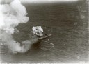
| Date: | 07 21 1921 |
|---|---|
| Description: | One of the most important moments in the history of American aviation - the sinking of the captured German battleship "Ostfriesland" by American bombers of... |

| Date: | |
|---|---|
| Description: | An aerial view of the port and a section of the city showing a large boat, a railway depot, a park plaza and a grid of city streets with large buildings. |
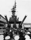
| Date: | 1957 |
|---|---|
| Description: | Ceremony beneath the guns on board the U.S.S. Wisconsin. A number of spectators and sailors are seated in the foreground, and uniformed sailors line... |

| Date: | 1770 |
|---|---|
| Description: | The south west sheet of a four sheet map of Virginia, showing the counties, mountains, rivers, court houses, a few cities, and mills. A few Plantations ar... |

| Date: | 1762 |
|---|---|
| Description: | Map of Virginia and parts of Maryland. It shows borders, boundary lines, Native American tribes and land, towns, forts, roads, mountains, waterfalls, bays,... |

| Date: | 1781 |
|---|---|
| Description: | Map of the southern portion of the Chesapeake Bay and surrounding lands. It shows counties, a few cities and towns, forts, roads, islands, topographical fe... |
If you didn't find the material you searched for, our Library Reference Staff can help.
Call our reference desk at 608-264-6535 or email us at: