 Filter: Categories of Wisconsin Historical Images
Filter: State of Virginia
Filter: Subject of land
Filter: Subject of arts
Filter: Categories of Wisconsin Historical Images
Filter: State of Virginia
Filter: Subject of land
Filter: Subject of arts
| Date: | 1929 |
|---|---|
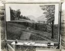
| Description: | A backdrop from the set of the Fox Hearst film "Romance of the Reaper." The film was produced by International Harvester at Walnut Grove to celebrate the R... |
| Date: | 1929 |
|---|---|
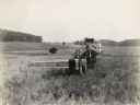
| Description: | A production still from the Fox Hearst film "Romance of the Reaper." The film was produced by International Harvester at Walnut Grove to celebrate the Reap... |

| Date: | 1929 |
|---|---|
| Description: | A production still for the Fox Hearst film "Romance of the Reaper". The film was produced by International Harvester at Walnut Grove to celebrate the Reape... |

| Date: | 1929 |
|---|---|
| Description: | A production still for the Fox Hearst film "Romance of the Reaper". The film was produced by International Harvester at Walnut Grove to celebrate the Reape... |

| Date: | 1929 |
|---|---|
| Description: | A production still of the Fox Hearst film "Romance of the Reaper." The film was produced by International Harvester at Walnut Grove to celebrate the Reaper... |

| Date: | 1770 |
|---|---|
| Description: | The south west sheet of a four sheet map of Virginia, showing the counties, mountains, rivers, court houses, a few cities, and mills. A few Plantations ar... |

| Date: | 1671 |
|---|---|
| Description: | Map of Virginia depicting the discoveries detailed by John Smith in his exploration of the region. It shows Jamestown, Native American tribes and villages,... |

| Date: | 1755 |
|---|---|
| Description: | Map of Virginia and parts of Maryland, North Carolina, and New Jersey. It shows borders, boundary lines, some Native American land, counties, cities, towns... |

| Date: | 1762 |
|---|---|
| Description: | Map of Virginia and parts of Maryland. It shows borders, boundary lines, Native American tribes and land, towns, forts, roads, mountains, waterfalls, bays,... |

| Date: | 1781 |
|---|---|
| Description: | Map of the southern portion of the Chesapeake Bay and surrounding lands. It shows counties, a few cities and towns, forts, roads, islands, topographical fe... |

| Date: | |
|---|---|
| Description: | Three-quarter view towards the front and left side of a log building with a peaked roof which is built into a hill. The left side of the building is below ... |
If you didn't find the material you searched for, our Library Reference Staff can help.
Call our reference desk at 608-264-6535 or email us at: