Filter: Categories of Wisconsin Historical Images
Filter: State of Virginia
Filter: Subject of land
Filter: Categories of Wisconsin Historical Images
Filter: State of Virginia
Filter: Subject of land
| Date: | |
|---|---|
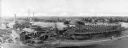
| Description: | Elevated view of a densely settled town in the Shenandoah valley. In the background are the foothills of the Appalachian mountains. Caption reads, "Bird's-... |
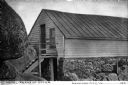
| Date: | |
|---|---|
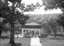
| Description: | View looking down into a covered shelter, built in the early 1900's, for Massanetta Springs. A group of people are sitting in the shelter which is in a cou... |
| Date: | |
|---|---|
| Description: | An aerial view of the University of Virginia. The main building in the foreground references the Roman Pantheon and features a Classical-style porch, colum... |
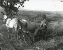
| Date: | 06 21 1899 |
|---|---|
| Description: | A man is using a McCormick New 4 mower pulled by two horses to work on the farm land at Monticello. |
| Date: | |
|---|---|
| Description: | Exterior of Peaks of Otter Lodge. The wooden shelter, built into the surrounding rock, features a doorway in the stone, ground floor, and one in the wooden... |
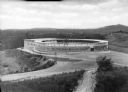
| Date: | |
|---|---|
| Description: | Elevated view of the exterior of Liberty Heights Swimming Pool, a circular structure standing on a hilltop. Stairs lead to a door labeled, "Exit," where a ... |

| Date: | |
|---|---|
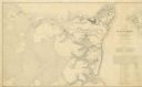
| Description: | A hand-drawn map of Indian boundary lines in southwest Virginia. It also includes the Duck River and the Elk River. |

| Date: | |
|---|---|
| Description: | Elevated view of a road and river winding through a mountainous landscape, seen from Waterlick White Hotel. Caption reads: "View from Hotel, Waterlick whit... |

| Date: | |
|---|---|
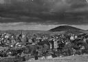
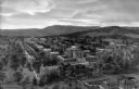
| Description: | Elevated view of a colony of residences in a mountain setting. |
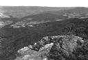
| Date: | |
|---|---|
| Description: | Valley view from Skyline Drive. Four people on horseback look down upon the farmland of the valley from a rocky ledge. |

| Date: | |
|---|---|
| Description: | Elevated view of the Blue Ridge Terrace, a large hotel on a mountain overlooking the valley. Cars are parked near the road, and three men are gathered on t... |

| Date: | |
|---|---|
| Description: | Visitors walk along a path underneath a natural land bridge. |

| Date: | |
|---|---|
| Description: | Entrance to the tourist attraction of Lord Cornwallis Cave. The sign above the door reads, "Admission 10¢." Initials are inscribed in the dirt wall. |

| Date: | |
|---|---|
| Description: | View down hill toward the York River with small homes on its banks. Long piers stretch into the river. |

| Date: | 1861 |
|---|---|
| Description: | This map shows Manassas during the First Battle of Bull Run, in which the 2nd Wisconsin Infantry fought, and the Leesburg area, the site of the Battle of B... |
| Date: | 1862 |
|---|---|
| Description: | This map illustrates the official plan for the siege of Yorktown, Virginia, and indicates the headquarters of Generals McClellan, Porter, Woodbury, and Hei... |

| Date: | 1863 |
|---|---|
| Description: | This map shows roads, railroads, settlements, farms with owners' names, vegetation, streams, and fords in Culpeper County region during the Civil War. A ma... |

| Date: | 1862 |
|---|---|
| Description: | The first in a series of three maps of the Virginia Peninsula. This map details the area from Williamsburg south to Fortress Monroe at Hampton Roads and sh... |

| Date: | 1862 |
|---|---|
| Description: | The second in a series of three maps of the Virginia Peninsula. This map details the area from Williamsburg north to West Point. |
If you didn't find the material you searched for, our Library Reference Staff can help.
Call our reference desk at 608-264-6535 or email us at: