 Filter: Categories of Wisconsin Historical Images
Filter: State of Virginia
Filter: Subject of military art and science
Filter: Subject of intellectual life
Filter: Categories of Wisconsin Historical Images
Filter: State of Virginia
Filter: Subject of military art and science
Filter: Subject of intellectual life
| Date: | 07 21 1921 |
|---|---|
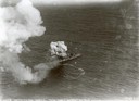
| Description: | One of the most important moments in the history of American aviation - the sinking of the captured German battleship "Ostfriesland" by American bombers of... |

| Date: | 07 1862 |
|---|---|
| Description: | Lieutenant J.N.P. Bird, with newspaper, and Lieutenant Lefler, in front of Lieutenant Bird, with troops of the 7th Wisconsin Company I of the 7th Wisconsin... |

| Date: | 07 04 1776 |
|---|---|
| Description: | Hand-drawn map of the area where the Battle of Black's Fort took place. |

| Date: | 1925 |
|---|---|
| Description: | Aerial view of the site of the Confederate surrender in 1865. |
| Date: | 09 17 1862 |
|---|---|
| Description: | Proclamation of amnesty by Confederate Major General Loring, offering "Christian charity" to citizens who have been armed by the Union if they surrender th... |
| Date: | 09 24 1862 |
|---|---|
| Description: | A proclamation by Confederate Major General Loring asserting the soundness of Confederate currency and encouraging citizens to use it in trade and accept i... |

| Date: | 1957 |
|---|---|
| Description: | Ceremony beneath the guns on board the U.S.S. Wisconsin. A number of spectators and sailors are seated in the foreground, and uniformed sailors line... |

| Date: | 08 31 1779 |
|---|---|
| Description: | A handwritten "list of different inhabitants that consented to furnish the troops belonging to the state of Virginia." |

| Date: | 1762 |
|---|---|
| Description: | Map of Virginia and parts of Maryland. It shows borders, boundary lines, Native American tribes and land, towns, forts, roads, mountains, waterfalls, bays,... |

| Date: | 1781 |
|---|---|
| Description: | Map of the southern portion of the Chesapeake Bay and surrounding lands. It shows counties, a few cities and towns, forts, roads, islands, topographical fe... |
If you didn't find the material you searched for, our Library Reference Staff can help.
Call our reference desk at 608-264-6535 or email us at: